Kansas Paddler's Guide - Volume 2
revised:
01/16/2012
Kansas River
Click
onto a town to see hot-linked River Maps
 -
Map(221KB) of the Historical and Cultural Sites
along the Kaw, courtesy of USGS.
-
Map(221KB) of the Historical and Cultural Sites
along the Kaw, courtesy of USGS.
NOTES:
- See the KANSAS PADDLER Home Page (http://www.kansas.net/~tjhittle) for (Kansas USGS) river flow information and Kansas Canoe Association trip
information.
- For revisions/updates/or additions to the list below, Email: tjhittle@kansas.net
- Remember that all Kansas streams but the Kansas River, Arkansas River, and Missouri
River flow over "private property", as interpreted by the Kansas Supreme Court.
Seek permission to float all private streams. Use your best judgement and
extreme caution to avoid the legal consequences of trespass.
- Class Difficulty Ratings are subjective. Use your own
judgement. There are elements of danger in each of the streams listed.
- Flow levels are easiest checked by logging onto the Kansas USGS Real Time Gauge link
under the KANSAS PADDLER Home Page
Water Conditions for River Runners page.
- Before planning your trip, return to the Kansas Paddler, to download the most current
edition
- Revised:01/16/2012
RIVER INFORMATION FORMAT
(The Kansas Atlas & Gazetteer by DeLorme is an indispensable
map guide for the information provided below)
 Stream Name:
 River/section Description
 - River Map (generally a large printable .jpg map)
 - River miles
- Put-in Description
- Take-out Description
- Anticipated Hazards
- Comments
- Minimum Recommended Flows / NOTE: Maximum Recommended flows are
the product of weather, skill level, experience, and craft, and are therefore not listed.
- Difficulty / Class(skill level):
Legend:
(RL) = River Left side when floating downstream / (RR) = River Right side when
floating downstream / USGS=United States Geological Survey / USACOE=United States Army
Corps of Engineers / KDWP=Kansas Dept. of Wildlife & Parks / RM= River Mile #
(numbering begins at the Missouri River confluence (RM 0.0 and ends at RM 170.5 in
Junction City, KS at the confluence of the Republican and Smoky
Hill Rivers)
NOTE: Kansas River Mileage based on a 1978 Bank Erosion Inventory
Study and Map by the USACOE.
RIVER ADVISORIES:
- Most Kansas streams have poor access. This means generally muddy bank
conditions, tall weeds, some steep and slippery slopes. Always watch for poison ivy
and stinging nettle. Wear long pants and tall rubber boots, then change into more
comfortable clothes at the closest sand or gravel bar after launching.
- Water quality is generally poor. Wash your hands and disinfect
prior to eating.
- Winds are always a concern on the Kansas River. Watch the weather
predictions prior to your float trip.
- Strainers and logjams are always a concern. Steer your craft away
from these.
- At minimum stream flows, considerable maneuvering will be required,
with frequent drags over shallow sand.
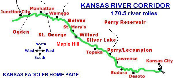
Kansas
River, aka Kaw River - (our only public canoeing stream in Northern Kansas):
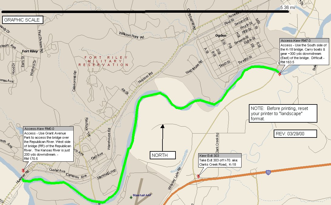
Junction City, KS to Ogden, KS
by-pass bridge
- River Map - JC to Ogden only
7.0 miles
Putin: Junction City,KSat the (Grant Ave. Park) bridge (RR) - on the Republican River - RM 170.5
Take-out: K-18
bridge, aka, Ogden bypass bridge (RL), RM 163.5. This access is on the
northwest side of the bridge in Riley County. Just follow the
fisherman's path to the river, staying underneath the bridge.
Caution: wind advisory; watch for downed trees & strainers / Access is long
and through high weeds & muddy banks
Good sand bar camping; passes through Ft. Riley; scenic; goes past First
Territorial Capital, can stop upstream and hike in (1/8 mi.) on their river
trail to see the museum. Watch for trail rails on the (RL) side.
1,100 cfs / Flow levels are easiest checked by logging onto the
Kansas USGS Real Time Gauge link under the KANSAS PADDLER Home Page Water Conditions for River
Runners page.
Class I
Ogden, KS to Manhattan, KS - new KDWP river access in 2011
- River Map - Ogden to
Manhattan only
14.2 - 15.9 miles, depending upon take-out options
Put-in: One mile below the K-18 bridge off K-18
& Walnut Street in Ogden - (RL), RM 164.5.
This new access is on river left & located in Riley County.
Just find the colorful apartments 1/2 mile south of the K-18 bridge.
Then follow the old dirt access road east to the river. It may be a
little hard to find but you will be thanking me later for pointing this new
river access out to you.
Take-out: K-177 bridge (RR) , aka Fairmont Park
Boat Ramp, off McDowell Cr. Rd at RM 149.3. This is a new
access, dedicated in 2008. You will love this access!
Alternate Take-out: Continue down to the Hwy 24
- Blue River confluence at RM 147.6 boat ramp and paddle upstream 3/4 mile. If Tuttle Cr.
Reservoir is releasing >4,000 cfs, DO NOT ATTEMPT TO PLAN TO PADDLE UPSTREAM.
Take-out upstream under the Hwy 177 Bridge, aka Fairmont Park Boat Ramp, instead.
Caution: wind advisory; watch for downed trees & strainers
Very scenic; cuts through Flint Hills; great camping
1,100 cfs / At minimum stream flows, considerable maneuvering will
be required, with frequent drags over shallow sand. Flow levels are easiest checked
by logging onto the Kansas USGS Real Time Gauge link under the KANSAS PADDLER Home Page Water Conditions for River
Runners page.
Class I
Manhattan, KS to St. George, KS
- River Map -
Manhattan, KS to St. George, KS only
11.0 miles (10.3 on the Kaw and .7 on the Big Blue River)
Hwy 24 -Blue river boat ramp & access (RR) RM 147.6 - good access 3/4 mile downstream to
the Kansas River
St. George River Park via the sewer treatment
plant road &
access (RL) RM 137.3 - Access is now great due to a brand new concrete
boat ramp & parking area, developed by the City of St. George. This was
a product of the efforts of the Westar Energy Green Team, Kansas Canoe
Association, Friends of the Kaw, American Flyfishers Association, Hittle
Landscape Architects, and numerous private donations. Directions: After
entering St. George, KS on the Old Military Trail Rd, continue past the Post Office on 1st street, to Lincoln
street (landmark is the old gas station) and turn south on this road near
Blackjack Creek going about 1/3 mile over the RR tracks and to the sewer
treatment plant & new river park. It even has a bathroom.
Caution: wind advisory; watch for downed trees & strainers
Great sandbar camping
1,100 cfs / At minimum stream flows, considerable maneuvering will
be required, with frequent drags over shallow sand. Flow levels are easiest checked by
logging onto the Kansas USGS Real Time Gauge link under the KANSAS PADDLER Home Page Water Conditions for River
Runners page.
Class I
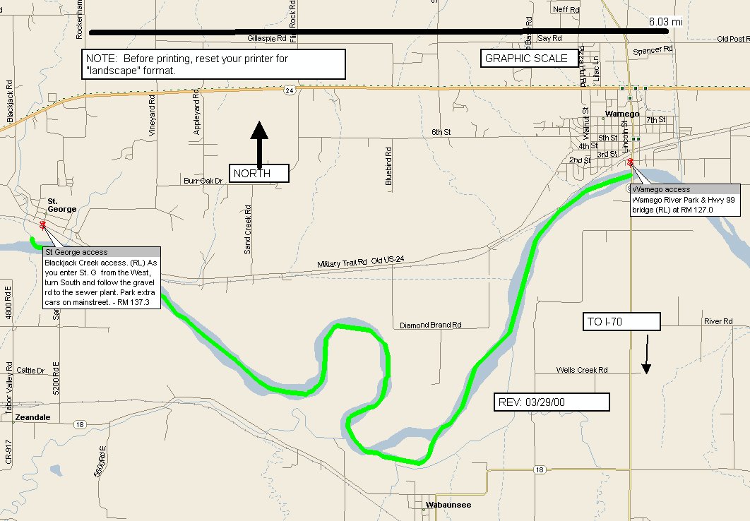
St. George, KS to Wamego, KS
- River Map - St.
George, KS to Wamego, KS only
10.3 miles
Put-in: St. George River Park via the Blackack
Creek & sewer
treatment plant road &
access (RL) RM 137.3 - This new access is now A-1 due to a brand new concrete
boat ramp & parking area, developed by the City of St. George. This was
a product of the efforts of the Westar Energy Green Team, Kansas Canoe
& Kayak Association, Friends of the Kaw, American Flyfishers Association, Hittle
Landscape Architects, and numerous private donations. Directions: After
entering St. George, KS on the Old Military Trail Rd, continue past the Post Office on 1st street, to Lincoln
street (landmark is the old gas station) and turn south on this road near
Blackjack Creek going about 1/3 mile over the RR tracks and to the sewer
treatment plant & new river park.
Take-out: New Hwy 99 Wamego bridge,
aka River Park Boat Ramp & access (RL) - RM 127.0. This is a brand new
access, dedicated in 2008. You will love this access too!
Caution: wind advisory; watch for downed trees & strainers / Access is fair
Good sandbar camping
1,100 cfs / At minimum stream flows, considerable maneuvering will
be required, with frequent drags over shallow sand. Flow levels are easiest checked by
logging onto the Kansas USGS Real Time Gauge link under the KANSAS PADDLER Home Page Water Conditions for River
Runners page.
Class I
Wamego, KS to
Belvue, KS
11.5 miles
Put-in: Wamego - Hwy 99 bridge (RL) - RM 127.0
-
Take-out: Shoeman Rd bridge, Belvue (RL) RM 115.5 - steep bank climb; use ropes to help
Alternate Shorter Take-out: Alternate access at the Vermilion River bridge
(RL) - RM 121.5
Caution: wind advisory; watch for downed trees & strainers / Access is fair
Good sandbar camping
1500 cfs / At minimum stream flows, considerable maneuvering will be
required, with frequent drags over shallow sand. Flow levels are easiest checked by
logging onto the Kansas USGS Real Time Gauge link under the KANSAS PADDLER Home Page Water Conditions for River
Runners page.
Class I
Belvue, KS to
Maple Hill, KS
11.4 miles
Put-in: Shoeman Rd bridge (RL) - RM 115.5 - steep bank climb; use ropes to help
Take-out: Maple Hill bridge (RL) - RM 104.1 - steep bank climb; use ropes to help
Caution: wind advisory; watch for downed trees & strainers / Access is poor
Good sandbar camping
1500 cfs / At minimum stream flows,
considerable maneuvering will be required, with frequent drags over shallow sand. Flow
levels are easiest checked by logging onto the Kansas USGS Real Time Gauge link under the
KANSAS PADDLER Home Page Water
Conditions for River Runners page.
Class I
Link to
Maple Hill community - shops &
places to eat near the Kansas River
Maple
Hill, KS - Topeka, KS
Opt 1=9.1 miles / Opt. 2=25.6 miles
Maple Hill bridge (RL) - RM 104.1 (steep bank
climb; use ropes to help) - has limited parking
Link to
Maple Hill community - shops &
places to eat near the Kansas River
Take-out opt. 1: Silver Lake
access (RL) - RM 95.0.
This also is a steep banked primitive access. Take ropes along.
Take-out opt 2: Seward Ave. boat
ramp (RR) - RM
78.5
This is probably the least attractive section of the Kaw.
Also takes you past the Oakland Sewage Treatment plant outlet in Topeka, KS.
2000 cfs /
Flow levels are easiest checked by
logging onto the Kansas USGS Real Time Gauge link under the KANSAS PADDLER
Home Page Water Conditions for River
Runners page.
Class I / NOTE: above low head dam hazards
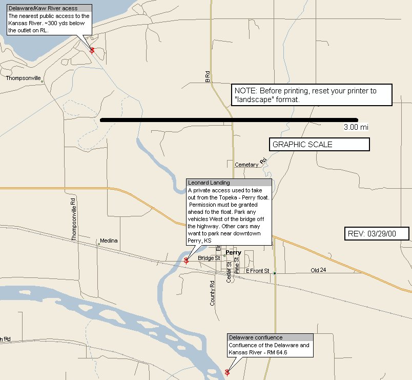
Topeka, KS - Perry, KS
- River Map - Perry
Access only
- River Map - Topeka-Perry only
14.6 miles (13.9 miles on the Kaw and .7 up the
Delaware River to Perry, KS)
Put-in: Seward Ave - boat ramp (RR) - RM 78.5
Take-out: The Delaware River (RL) at RM 64.6 then paddle up .7
mi. mile to Leonard's Landing, Perry, KS (NOTE: Ask for permission to access, prior
to launch)
Caution: wind advisory; watch for downed trees
& strainers / Access is poor
Good Sandbar camping
1500 cfs /
Flow levels are easiest checked by
logging onto the Kansas USGS Real Time Gauge link under the KANSAS PADDLER
Home Page Water Conditions for River
Runners page.
Class I
Perry, KS - Lawrence, KS
-
River Map -
Lawrence River Park access only
-
River Map - Perry
- Lawrence only
15.0 miles (4.0 miles down the Delaware River and 11.0
miles on the Kansas River)
Perry Reservoir - Outlet Park (on the Delaware
River (RR), paddle down to the Kansas River - RM 64.6
Lawrence River Park(RL) - RM 53.6
Caution: wind advisory; watch for downed trees
& strainers / Access is moderate
Great sandbar camping, scenic section
1500 cfs /
Flow levels are easiest checked by
logging onto the Kansas USGS Real Time Gauge link under the KANSAS PADDLER
Home Page Water Conditions for River
Runners page.
Class I
Lawrence, KS - Desoto, KS
23.5 miles
Below Bowersok Dam (RL) - in Lawrence, KS - RM 50.0 /
Take
2nd St. (Hwy. 40/59) north to the first stoplight at Locust Street by Johnies'
Tavern. Turn right (east) on Locust and go 5 blocks to 7th St. Turn right
(south) on 7th and follow 3 blocks until it ends at a hard left at the river levee.
Follow the turn left and go east one long block on Ash to 8th St. Turn right and go
about half a block to the River. The access has a good size parking lot, concrete
ramp and a trash barrel.
Cedar Creek Access(RR) - East of Desoto, KS - RM 26.5
Caution: wind advisory; watch for downed trees & strainers /
Access is poor
Comments
1500 cfs /
Flow levels are easiest checked by
logging onto the Kansas USGS Real Time Gauge link under the KANSAS PADDLER
Home Page Water Conditions for River
Runners page.
Class I
Desoto, KS - Kansas, City, MO
26.5 miles
Cedar Creek Access
(RR) - East of Desoto, KS - RM 26.5
Kaw Point (RR) RM 0.0 - at the Kansas River &
Missouri River confluence
Caution: wind advisory; watch for downed trees, strainers, and boulder dam
immediately below the I-435 bridge (portage on river left) / Access is moderate
CAUTION: The boulder dam immediately below the I-435 bridge is a formidable
portage for loaded boats. Take your time and use extreme caution when portaging on
river left.
Comments
1500 cfs / Flow levels are easiest checked by
logging onto the Kansas USGS Real Time Gauge link under the KANSAS PADDLER
Home Page Water Conditions for River
Runners page.
Class I
(See the KANSAS PADDLER Home Page for the most current trip/event
schedules) www.kansas.net/~tjhittle
[Home] / [Mega-Index] / [Water Conditions]
You are visitor 108551 to this page
 - River Map - JC to Ogden only
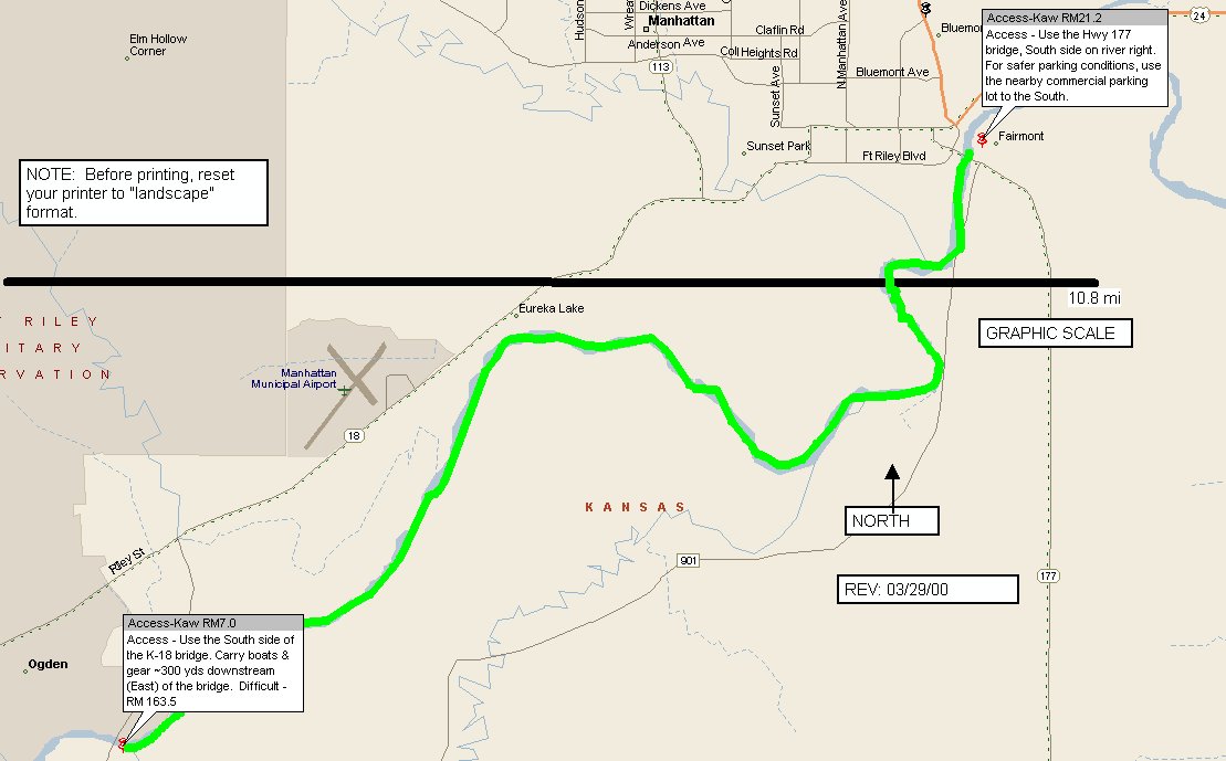 - River Map - Ogden to
Manhattan only
- River Map - Ogden to
Manhattan only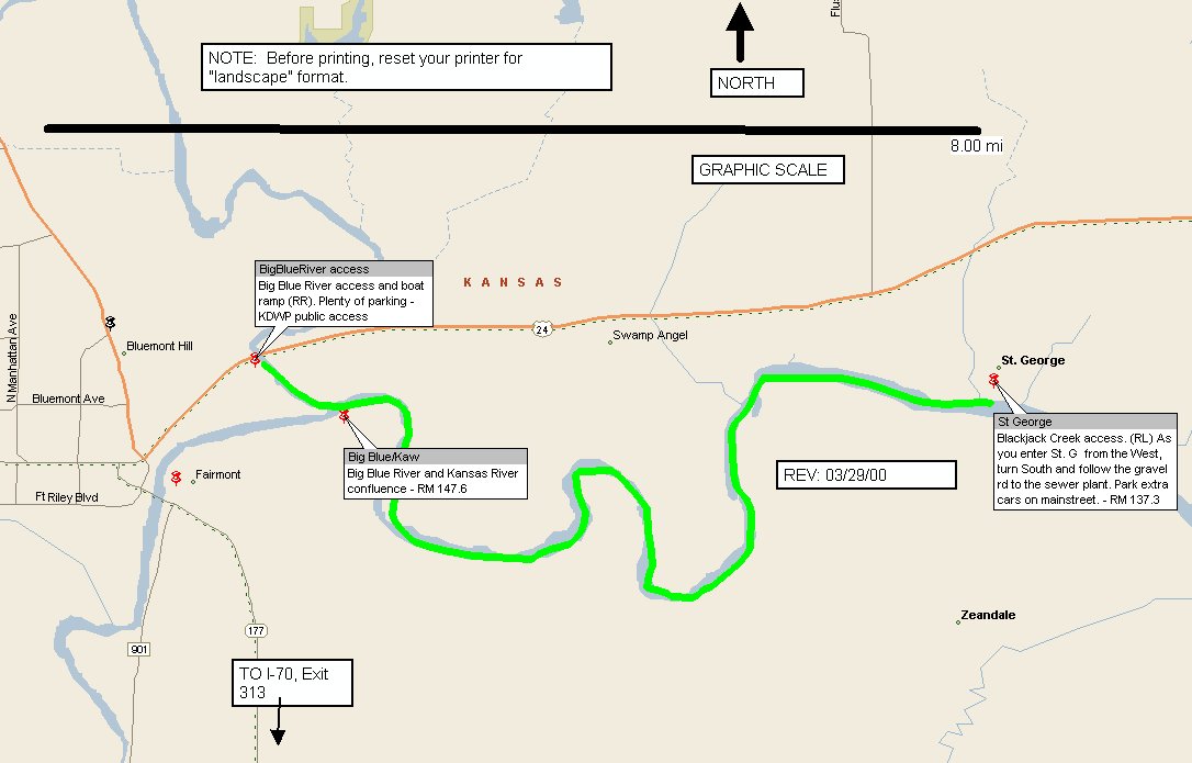 - River Map -
Manhattan, KS to St. George, KS only
- River Map -
Manhattan, KS to St. George, KS only
 - River Map - St.
George, KS to Wamego, KS only
- River Map - St.
George, KS to Wamego, KS only
 - River Map - Perry
Access only
- River Map - Perry
Access only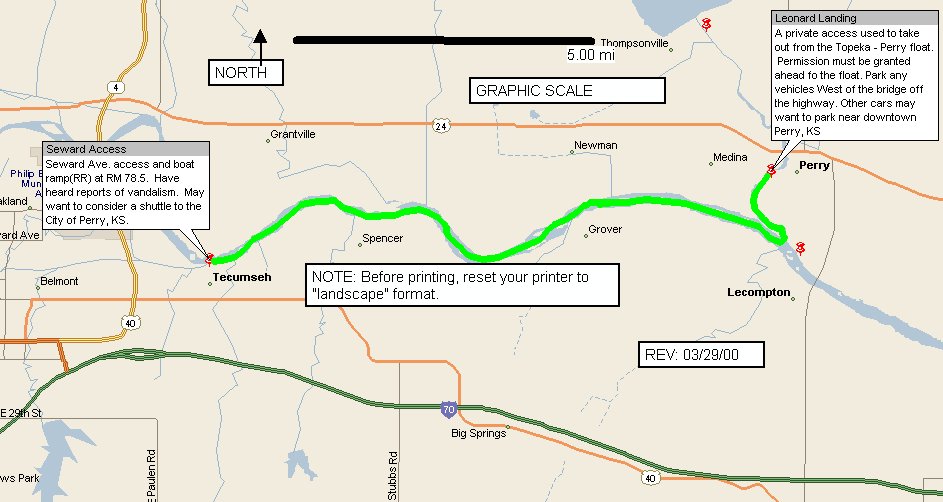 - River Map - Topeka-Perry only
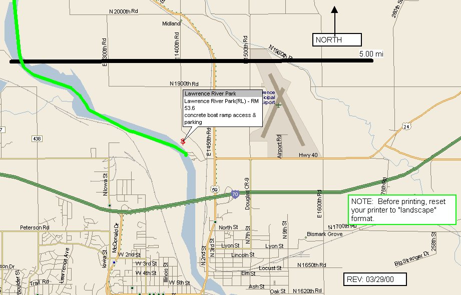 -
River Map -
Lawrence River Park access only
-
River Map -
Lawrence River Park access only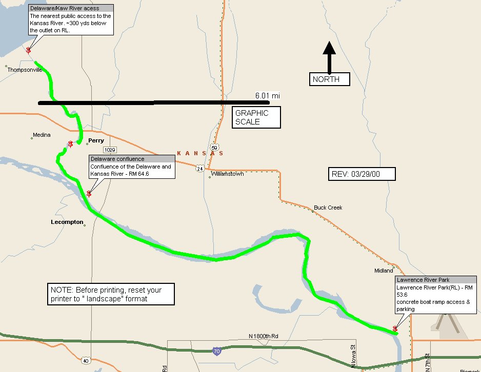 -
River Map - Perry
- Lawrence only
-
River Map - Perry
- Lawrence only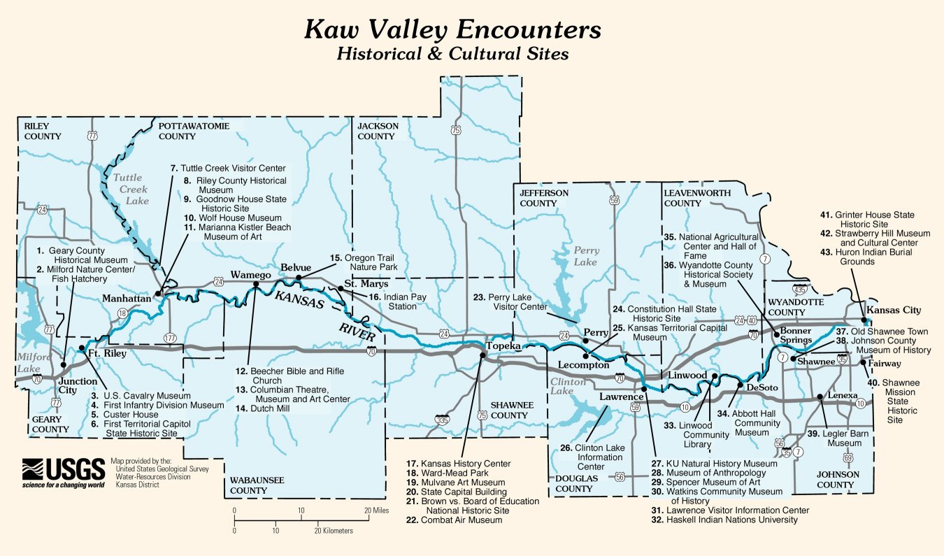