
Home Page Storm Chasing Storm Chase Info for Eastern Kansas Favorite Links
Central US Radar Click Maps Kansas Radars May 29-30, 1879 Tornadoes
|
Home Page Storm Chasing Storm Chase Info for Eastern Kansas Favorite Links Central US Radar Click Maps Kansas Radars May 29-30, 1879 Tornadoes |
|
J. P. Finley's Full Path Map of the first Irving TornadoPath of the first Irving Tornado plotted on a modern day mapPaths of the May 29 and 30, 1879 Tornadoes
PAGE 37 -- TORNADOES OF MAY 29 AND 30, 1879.THE IRVING TORNADO(ES).The present storm, which proved to be the longest of any examined, and also the most destructive, especially to life, first appeared over the heavy rolling prairie of Bala Township, Riley County, Kansas, near the source of no less than five creeks, which flow to the SE., ESE., E., NE., and NNE. Over a series of ridges alternating with heavily wooded bottoms from 60 rods (302 m) to a mile (1.609 km) in width developed the first stages of the storm. From the house of Mr. T. Naninaga, near Walnut Creek, where the first destruction occurred, there was observed forming in the SW. and NW. about 4 p. m. dark, heavy clouds. Their appearance was considered nothing unusual except that they came up very suddenly, first from the NW. and then the SW. In fact, a storm was rather expected, because of the sultry and close condition of the atmosphere, which had continued most of the day with a southerly wind. In a short time the clouds which had come up so quickly and quietly were thrown into the most terrible commotion; huge black masses mingled with lighter clouds, would roll upward in front of and between the opposing currents, the latter sometimes shooting upward with lightning velocity. Rain and large hail had already commenced to fall, and in about fifteen minutes the whirlwind of destruction formed, having the shape of a huge elephant’s trunk, and gradually lowered itself towards the ground. As it passed (yet above the surface) to the W. of Mr. Naninaga’s, his corn-cribs and stables were destroyed, and about 150 bushels of corn strewn along the prairie. The débris was all carried to the NE., N., and NW. The house was severely racked by a SW. wind, but not destroyed. The storm next unroofed the house and stables of Mr. Peter Nelson, half a mile (0.805 km) to the NE., carrying the débris along the track to the NE. for several hundred yards. Mr. C. A. Gouranson, the last resident on the high prairie before reaching what is called "Hanson’s Ravine," which cuts off from the "divide" running ENE. towards Walnut Creek, was next reached, and his house unroofed. The smaller and weaker outbuildings were entirely demolished. The storm, from its inception, had followed the "divide," running from SW. to NE., between Walnut Creek to the E. and South Otter Creek to the W., a distance of about 7 miles (11.265 km). It then descended the "Ravine" and northern slope of the "divide" to Fancy Creek, a large stream running from NW. to SE. and emptying into the Big Blue River at Randolph. At this point a smaller funnel cloud shot off from the main one and passed down the "Ravine" to the NE., while the latter continued down the slope of the "divide" to the N. In the bottom of the "Ravine," the house of Mr. Thumbloum was simply turned over to the NW., and the roof blown off from the house of Mr. Lewis Peterson; both buildings stood E. of the storm’s center about 20 rods (101 m). The house of Mr. Lewis Hanson, standing W. of the storm’s center 35 rods (176 m), was deprived of the kitchen, which was attached to the S. end of the building, the largest portion of it being taken up into the air and scattered, no one knew where. The small funnel cloud now reached the timber on Fancy Creek, 2-1/2 miles (4.023 km) NW. of Randolph, which it destroyed, with terrible fury, embracing all of the irregularities of the creek’s course for a width of half a mile (0.805 km). As the tornado first crossed the creek the large stone barn of Mr. E. Secrest was unroofed and the S. gable-end blown in. This building stood on the southern side of the wide bottom lands which spread out to the N. and E. for nearly a mile and a half (2.414 km). NE. of the barn and nearly across the valley, a new and large church building was completely wrecked, and the débris carried forward in the track of the storm for one-fourth of a mile (0.402 km). This, to all appearances, was the last destruction committed by the small funnel cloud. The large one, before crossing Fancy Creek, struck the large two-story house of Mr. Weisdanger, entirely destroying the second story and roof, except a portion of the E. wall. The building was situated 25 rods (126 m) W. of the storm’s center and first struck by the wind from the N., the débris being carried to the W., SW., and S. Large stones weighing from 150 to 200 pounds were carried about PAGE 38 -- TORNADOES OF MAY 29 AND 30, 1879.300 feet (91.4 m). Out-buildings standing E. of the house and nearer the storm’s center were more completely demolished. The house of Mr. Charles Peters, still farther W. of the storm’s center, was considerably racked, but not otherwise damaged. In crossing through the heavy timber on Fancy Creek, the destruction was even more fearful than that produced by the smaller tornado. Large oaks 3 feet (0.9 m) in diameter were broken off like pipe-stems, and tough elms nearly as thick were twisted into ropes. The two clouds were now on the northern side of Fancy Creek close to the mouth of North Otter. Here the two tracks which had previously been separated about 1-1/2 miles (2.414 km), merged into one. In this separation, I refer to the distance apart of the centers of the paths of greatest destruction, which corresponds very closely with the immediate diameter of the dark mass of clouds which formed the funnel. A strong wind prevailed between the two clouds of sufficient force to destroy small trees and overturn fences. It was quite a difficult matter to trace the respective courses of the two storm clouds, which were reported to have passed over this section, because their supposed points of meeting and separation were located among the ridges and heavily wooded ravines of several creeks, where the timber was more or less destroyed for a width of 2-1/2 miles (4.023 km). The storm certainly spread out here to an unusual width, but it was the case in all of the tornadoes where timber was encountered, caused in all probability by the opportunity offered to the revolving current of air to reach out and constantly find well suited material for its fury to feed upon, and also the fact that in a heavy forest the resistance offered to the developing energy of the storm cloud, as the inrushing currents of air attempt to reach the vortex of the whirl, is increased many fold, thereby concentrating from point to point the extreme limit of the tornado’s power. 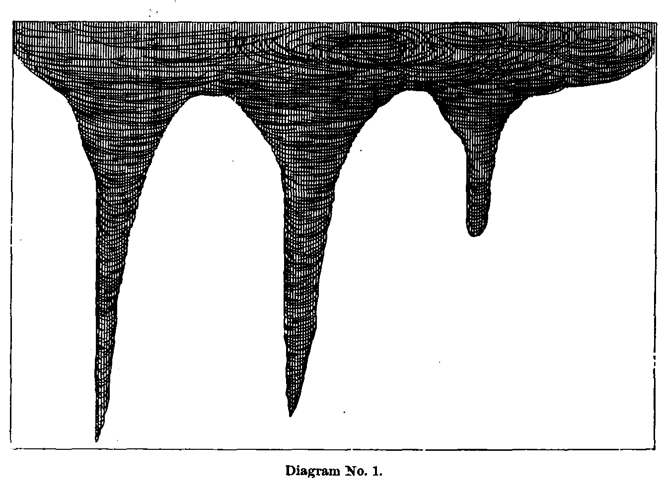 While
the storm was raging with demoniac fury in the timber, the people of Randolph
were looking on with fear and trembling. Mr. Alfred A. Parkerson, one among many
who watched the formation of the tornado at its inception SW. of Fancy Creek,
stated that during the day the wind had been from the S. most of the time, and
the weather unusually sultry. About 4 p. m. clouds began to gather in the W.
(wind still S.), with every appearance of a very hard storm. Shortly before 5 p.
m. a light breeze came from the N., which kept increasing in force and finally
blew very hard, when new and strange looking clouds seemed to dart up along the
horizon, from the S. around to the NW. with amazing rapidity, and rush towards a
very black spot, apparently about an acre (0.4 hectares)
in size, directly in the W. In about
five minutes a whirling motion was discernible in the black center, resulting in
the gradual development of a small funnel-shaped cloud, which wound itself
downwards towards the ground, where its tail, at the distance of between 3 and 4
miles (4.828 to 6.437 km) did not appear larger than a man’s leg. In about three minutes another
funnel formed on the right of the former, extending part way down to the ground,
and still another formed on the left, reaching entirely down to the ground.
(Diagram No. 1.) The main funnel appeared to be stationary, until these smaller
ones formed, when it moved with its companions towards Fancy Creek, causing the
people in the town to seek places of safety in cellars, "dug-outs,"
and wherever else they might hope for secure shelter. After passing by the heavy
belt of timber along the creeks the two smaller funnels disappeared. While
the storm was raging with demoniac fury in the timber, the people of Randolph
were looking on with fear and trembling. Mr. Alfred A. Parkerson, one among many
who watched the formation of the tornado at its inception SW. of Fancy Creek,
stated that during the day the wind had been from the S. most of the time, and
the weather unusually sultry. About 4 p. m. clouds began to gather in the W.
(wind still S.), with every appearance of a very hard storm. Shortly before 5 p.
m. a light breeze came from the N., which kept increasing in force and finally
blew very hard, when new and strange looking clouds seemed to dart up along the
horizon, from the S. around to the NW. with amazing rapidity, and rush towards a
very black spot, apparently about an acre (0.4 hectares)
in size, directly in the W. In about
five minutes a whirling motion was discernible in the black center, resulting in
the gradual development of a small funnel-shaped cloud, which wound itself
downwards towards the ground, where its tail, at the distance of between 3 and 4
miles (4.828 to 6.437 km) did not appear larger than a man’s leg. In about three minutes another
funnel formed on the right of the former, extending part way down to the ground,
and still another formed on the left, reaching entirely down to the ground.
(Diagram No. 1.) The main funnel appeared to be stationary, until these smaller
ones formed, when it moved with its companions towards Fancy Creek, causing the
people in the town to seek places of safety in cellars, "dug-outs,"
and wherever else they might hope for secure shelter. After passing by the heavy
belt of timber along the creeks the two smaller funnels disappeared.
PAGE 39 -- TORNADOES OF MAY 29 AND 30, 1879.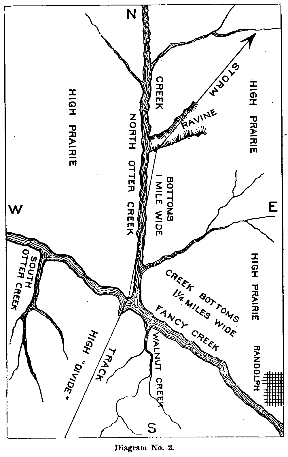 While
the tornado was passing the atmosphere surrounding the town of Randolph was
nearly calm, and occasionally large hail stones would fall straight to the
ground. The roaring of the storm, particularly when in the timber, was like the
rumbling of a thousand trains of cars. Mr. Henry Condray, of Randolph, who also
witnessed the three separate funnels, stated that during the day the wind was
blowing from the SE. stronger than for some weeks past, and at 4 p. m. light
rain fell but no hail. Half an hour after the tornado passed, a very heavy rain
came from the NW. with a remarkably cold wind. While
the tornado was passing the atmosphere surrounding the town of Randolph was
nearly calm, and occasionally large hail stones would fall straight to the
ground. The roaring of the storm, particularly when in the timber, was like the
rumbling of a thousand trains of cars. Mr. Henry Condray, of Randolph, who also
witnessed the three separate funnels, stated that during the day the wind was
blowing from the SE. stronger than for some weeks past, and at 4 p. m. light
rain fell but no hail. Half an hour after the tornado passed, a very heavy rain
came from the NW. with a remarkably cold wind.
The three funnels reported by these gentlemen, taken in connection with the supposed division of the storm’s track, as before stated, would seem to add largely to its probable occurrence. The division is not at all improbable, although the evidence furnished by the track as I saw it, which was many days after the storm, during which much of importance was obliterated, was not very strong. The storm left Fancy Creek near the mouth of North Otter, up which it passed for about 2 miles (3.219 km) to the N., first encountering a stone school-house about 70 rods (352 m) W. of the storm’s center, which it unroofed, carrying the débris to the W. and S. A portion of the E. wall was thrown inward, crushing the seats. The scholars were dismissed in a few minutes before the storm struck, going to neighboring houses for safety. Across the creek bottom, three-fourths of a mile (1.207 km) to the NE., stood the house of Mr. Heller, who saw the two funnels before spoken of unite after passing Fancy Creek, at a point about half-way between the church and school-house, but being terribly frightened from the expectation that his entire property was to be destroyed, he could recall very little concerning the particulars of the junction. His house barely escaped destruction, having a few shingles taken from the roof and a lightning-rod torn down. One-half mile (0.805 km) NNW. of the school-house the storm struck the house of Mr. Adam Schwein, which stood 250 feet (76.2 m) E. of the storm’s center, the cloud following the creek quite closely. The building was part stone and part frame; size, 16 by 28 feet (4.9 to 8.5 m) and one and one-half stories high. It was swept from the ground in an instant; no one seemed to know just how. Within were gathered at the time, three of the school-children besides the family, numbering eight in all, who were each and every one buried beneath the ruins. The father was badly bruised about the hips and hurt inwardly. The mother was not dangerously hurt, but an infant held in her arms was instantly killed. Their little daughter had her head crushed to a jelly by falling timbers. The remainder escaped with a few bruises. The clothing and furniture were totally ruined, shreds of the former being found one mile (1.609 km) from the house hanging in some tree-tops. Trees in the yard about the house were stripped to bare poles, and about them in several instances were wound the remnants of what were once whole garments. Beds, bedding, stoves, crockeryware [sic], and tinware [sic] were strewn along the track in shapeless ruin for hundreds of rods. The once happy home was desolated as if by fire--worse than fire, for it was the work of an instant--dashed into eternity and oblivion without the slightest opportunity for defense or escape. PAGE 40 -- TORNADOES OF MAY 29 AND 30, 1879.For the distance of a mile and a half (2.414 km) still farther N. the funnel cloud followed the stream, not as closely as before, but bearing off gradually more and more to the E. over the wide creek-bottoms, approaching the high rolling-prairie, which it soon reached by traversing a little wooded ravine that led out of the creek to the NE. (Diagram No. 2.) Throughout this ravine nearly every tree, both large and small, was either broken off, uprooted, or divested of every leaf and limb, and the earth fairly shorn of its covering of prairie grass. Throughout the storm’s entire course along North Otter Creek, in the heavy timber, trunks, limbs, and foliage were torn and shattered in the most fearful manner. Often the limbs of one large monster were found completely woven into those of its neighbor, and always in a direction from right to left. Many times the very center of the funnel appeared to have traversed the bed of the stream. The width of the path of greatest destruction averaged 275 feet (83.8 m). In several sections of the track which were closely examined, the trees generally lay pointing to the NE. and N., on the E. side of the center, lying across the track from E. to W. along the center, and on the W. side pointing to the WSW. and SE. There was no portion of the track where a well-developed whirl was not evidenced by the destruction. Hardly a tree or limb, unless partially rotten, but what bore some evidence of being twisted. Upon reaching the high prairie the cloud passed along the undulating surface for a mile and a half (2.414 km) until it reached the house of John Daly, standing a considerable distance W. of the storm’s center, which it unroofed, and, in like manner, the house of Mr. Ericson, one-fourth mile (0.402 km) to the NE. Both houses stood upon ground below the general level, yet not really in a ravine. A horse belonging to the last-named farmer and picketed out upon the prairie near the storm’s center, was carried up into the air, in all probability a considerable distance, as nearly every bone was broken when it fell. The tornado now lifted from the ground, which presented nothing in its topography materially differing from that already passed over since leaving the creek, and continued a direct NE. course over a section of the prairie very thinly inhabited. A few inconsiderable out-buildings were overturned, but no damage of importance was committed. Upon reaching the head of Swede Creek 5 miles (8.047 km) NE. of North Otter, the small house of a Bohemian standing upon a slight rise of ground was blown down, but not torn to pieces. Four miles (6.437 km) farther to the NE. the storm cloud reached the head of Timber Creek, where the stables and out-buildings belonging to Albert Beeckman were demolished, the funnel passing within 200 or 300 feet (61.0 to 91.4 m) of them to the W., but still above the ground. At both of these creeks the timber, even in the lowest parts of the bottoms, was not destroyed as heretofore; only the tops and an occasional trunk were found twisted or broken off, showing that the funnel had not dipped downward, but remained at the same level as upon the high prairie. The manner in which the buildings were destroyed also indicated the existence of the cloud above the surface. In every instance they were either simply unroofed of toppled over and crushed in falling, and the débris without an exception was thrown in the direction in which the storm was moving. Another important fact was the existence of only one current of air, in these cases of destruction, following in the wake of the cloud from the SW. The atmosphere was generally very quiet as the cloud came up, followed as it passed by a loud roar and a swift rush of the air as through a vacuum, not disturbing, however, the lightest article outside of its narrow path of from 60 to 100 feet (18.3 to 30.5 m). At the distance of 1-1/2 miles (2.414 km) to the NE., the tornado crossed the line of Marshall County, partially destroying the house of Nathan Wentworth, situated 80 rods (402 m) SW. of the point where the ground began to descend to Game Fork Creek. The cloud commenced to descend again to the surface and widen its path of destruction. Sixty rods (302 m) E. of Mr. Wentworth’s a school-house was unroofed and the débris carried to the NE. and N. The storm’s path was now one-fourth of a mile (0.402 km) wide, but the cloud is still upon the high prairie. The houses of Edward Wentworth, Gavin Reed, Robert Reed, and Wesley Cooper, situated in the bottom of a "draw" leading into Game Fork Creek from Timber Creek, in an ENE. direction, were next reached and fairly ground into pieces. Hardly a board 6 feet (1.8 m) long was left near the foundation of any of the buildings. The funnel as it passed from the high "divide" to the "draw" perceptibly widened at the bottom; but, without bodily swooping downward at once, PAGE 41 -- TORNADOES OF MAY 29 AND 30, 1879.it drew the buildings up into its vortex and then twisted them to pieces. The house of Robert Reed, 16 by 24 feet (4.9 to 7.3 m), and one and a half stories high, was lifted up as easily as a feather, and without at first cracking the timber. So quickly was it done, that before Mr. Reed, who was within, knew of his danger, the building had risen a height of 25 feet (7.6 m) or more. The house being then enveloped in darkness and not knowing what had happened, he started for the door, thinking it time to make good his escape, when, instead of stepping out upon the ground, as he expected, he fell the above-named distance, injuring himself severely. In passing down the "draw" the timber was torn in a dreadful manner, but leaving the clearest evidence of the existence of the characteristic whirl. The large frame building of Mrs. Noak, 80 rods (402 m) W. of the storm’s center, was torn to pieces and the débris carried to the SW. and SE. Mrs. Noak was instantly killed by a falling timber. The cloud now rose out of the "draw." [sic] and passed over a ridge about 75 feet (22.9 m) high to the NNE., overturning the house of Mr. Moses, but not otherwise injuring it. For the distance of 120 rods (604 m) it continued its course upon the high ground, when it reached another little "draw," running from SE. to NW., down which it passed for about 60 rods (302 m) to Game Fork Creek, making a descent of 175 feet (53.3 m), destroying the house of Mrs. Miller, at the foot of the bluff. Hardly a. vestige of the building remained. The tornado now encountered the timber again, making its usual havoc and widening out a distance of three-fourths of a mile (1.207 km). As it reached the southern bank of Game Fork Creek, a cluster of small houses, occupied, respectively, by Mrs. Brown, Henry Wilson, John Casey, and George Martin, were completely leveled to the ground. Mrs. Martin was killed by the falling timbers. Martin’s house stood on the extreme eastern edge of the storm’s center and Casey’s on the extreme western edge, one-half mile (0.805 km) apart. The débris from the former was carried to the NE., N., and NW., and of the latter to the W., SW., and SE. Mrs. Brown’s house stood E. of the storm’s center 45 rods (226 m), and the débris was carried to the NE. and N. Mr. Wilson’s heavy log house, one and a half stories high, and 15 by 30 feet (4.6 to 9.1 m), with a monster stone chimney on the W. end, occupied the center of the storm’s track. It was partially lifted, then thrown to the ground, and finally carried away, piece by piece. There were thirteen persons in the house at the time, mostly small children, not one of whom received a serious injury. The storm is now in the midst of the heavy timber lining the banks of the Game Fork Creek, where it spread out nearly a mile (1.609 km) in width, but the path of greatest destruction only averaged about 80 rods (402 m). The creek was first encountered where it made an abrupt bend to the NE. It flows from NW. to SE up to this point, when it bears 1¼ miles (2.012 km) to the N. in making 1 mile (1.609 km) to the E. Over his [sic] portion of its course the storm followed the stream closely. The eastern bank forms the highest bluffs in the surrounding county, rising abruptly over 200 feet (61.0 m), while the western side spreads out into a very fertile valley, one-fourth to one-half mile (0.805 km) in width, and but slightly raised above the bed of the stream. Along the western border of the valley the surface gradually rises 60 to 80 feet (18.3 to 24.4 m) to the high rolling-prairie beyond. This valley, running to the NE. 1½ miles (2.414 km), opens into the still broader and more beautiful valley of the Big Blue, stretching out from N. to S. a distance of from 4 to 5 miles (6.437 to 8.047 km). That portion of this rich and fertile valley bounded on the S. by Game Fork Creek, on the N. and E. by the Big Blue River, and on the W. by a high "divide," formed the site of ill-fated Irving, a very pleasant and thriving village of 300 inhabitants. There were only three openings to this natural amphitheater (3 miles (4.828 km) long by 2 miles (3.219 km) wide), one from the SW. by way of Game Fork Creek, and the other two from the NW. and SE., by way of the Big Blue. Going back to the funnel cloud where we left it at is entrance upon Game Fork Creek, we find that it followed the bed of the stream very closely, hugging the eastern bluffs with such tenacity that it ripped up nearly every tree along their sides and withered the tough prairie grass. Persons who watched its progress along this portion of its track stated that the demoniac fury of the cloud was appalling; whirling with most frightful rapidity, the intense black column would at times seem to level the whole bluff as it disappeared from view within the huge rolling mass of darkness. The eastern bank, covered with a luxuriant growth of timber, would, as the cloud moved along, successively emerge from its awful baptism swept clean to the soil. While this terrific manifestation of force was going on along the stream, westward over the valley, a distance of 60 rods (302 m), only a gentle wind was experienced. PAGE 42 -- TORNADOES OF MAY 29 AND 30, 1879.The first house destroyed on the creek bottom was Mrs. Brumbell’s, standing on the western bank, not more than 100 feet (30.5 m) W. of the storm’s center. All that was left of the building, 18 by 20 feet (5.5 to 6.1 m), and one and a half stories high, were five or six of the foundation stones and part of an old stove. The remainder of the house might have been found anywhere on the bluffs, valley, or about the village beyond. At the distance of a quarter of a mile (0.402 km) to the NE., close to the western bank of the creek and in a little depression forming one of the irregularities of the creek’s bank, stood the small house of Mr. Buckmaster; not one vestige remained to mark its former resting place. The débris was swept into the vortex to the E. and carried no one knew where. Of course it required but comparatively a small manifestation of force to destroy the frail building, as it was diminutive and loosely put together. But this condition made it all the worse for the ill-fated family within, consisting of the parents and four children. Mr. Buckmaster was left upon the ground near the foundation, with fragments of his pants and shirt hanging to him, and dangerously wounded. One of the girls was carried 30 rods (151 m) to the E., another 40 rods (201 m) to the S., another 25 rods (126 m) to the NW., and the last, 35 rods (176 m) to the NW. The mother was carried NE. 45 rods (226 m). Each one of the last five were found dead and perfectly devoid of clothing. At this point the creek turns directly to the E, the high bluff’s now forming the S. bank, and the cloud which had followed its course for 1½ miles (2.414 km) while the creek ran to the NE., now left it at the SW. gateway to the town, and started across the flats for the latter, 1 mile (1.609 km) to the NE. The first house encountered as it left the creek was the stone building of Mr. Ambrose Ship, standing 54 rods (272 m) SE. of the storm’s center. The building was unroofed and the débris carried to the NW. Directly opposite Mr. Ship’s, to the W., stood the large stone house of Rev. Mr. Griffiths, Presbyterian minister at Irving. The kitchen on the W. side of the house was unroofed; the cupola and part of the roof of the main building were also carried away. The débris from the former lay to the SW. and SE., while that of the latter lay to the NE. The house stood on the extreme western edge of the storm’s path, whose width was now about three-quarters of a mile (1.207 km). These two houses stood at the very entrance to the valley of the Game Fork, SW. of Irving. The funnel cloud narrowed its path of destruction about one-half after leaving this point. I will now commence to number the houses that were destroyed within the city limits of Irving in the order in which the storm severally met them. These numbers will also appear upon the map of the city accompanying this report. No. I, or that owned by Mr. John Gale, situated 20 rods (101 m) NE. of Mr. Ship’s, and about the same distance SE. of the storm’s center, was unroofed and the walls torn down to the first story. The débris was carried to the NE. and N. It was a very old building and considerably out of repair. Mrs. Gale’s baby was carried out of the house into a Wheatfield to the NE., a distance of 30 rods (151 m), and a little girl carried E. into a small ravine, distant 28 rods (141 m). Four other members of the family, including the father and mother, were carried to the E. at distances varying from 10 to 15 rods (50 to 75 m), and their clothing torn into shreds and partially stripped from their bodies. No. II, Mr. Gallop’s house, stood within the path of the storm’s center; size, 16 by 28, and one and a half stories high, with an addition to the S. 12 by 14 and one story high. The entire house was lifted up bodily, containing the family of five persons, to a height of about 20 feet (6.1 m) above the ground, without so much as removing the chimney. It was then carried 125 feet (38.1 m) to the NE., when it was twisted into pieces and the débris scattered to the ENE. and NW. The family came down to the ground upon the lower floor as it fell out, while the upper portion of the house was carried away above their heads. This was evidenced, aside from their own testimony, by the fact that most of their wounds were upon the scalp, or running from the neck over the head. The mother was carried into a cornfield 40 rods (201 m) to the NE., two of the children 20 rods (101 m) to the E., and the father and one child 15 rods (75 m) to the NE. All were nearly stripped of their clothing and covered with black mud, but none killed. The cloud was now traversing the southern skirts of the town along the open flats, which course, had it been maintained, would have saved the trembling inhabitants and their valuable property from the terrible destruction soon to follow. Its course was ENE., sweeping along above the ground for a distance of 1½ miles (0.457 km), when the new and costly buildings (No. III) of Captain Armstrong were reached, standing a little W. of the storm’s center. The house was a large two-story structure with mansard roof, and, with the barn, cost $9,000 [sic]
PAGE 43 -- TORNADOES OF MAY 29 AND 30, 1879.The former was first struck by the wind from the NE. and turned completely over to the SW., when it was torn to pieces and the débris carried to the SE. and E. from one-fourth to three-fourths of a mile (1.207 km). The barn, 100 feet (30.5 m) SW. of the house, was destroyed in a similar manner and in all probability by the same current, which continued its whirl to the left, as the débris of the house was carried to the S., SE., and E. A new and heavy lumber wagon loaded with 1,000 feet (304.8 m) of lumber, standing half way between the house and barn, was carried away and no trace found of it. A new top buggy near by was completely wrecked, and portions of it scattered along the track for half a mile (0.805 km). Many were the curious freaks of the storm at this house, which space will not permit me to relate. Letters from Captain Armstrong were found on the farm of Mr. Frank Bard 7 miles (11.265 km) to the NE. Lightning-rods and wire fencing were wound into balls or twisted into ropes. Tin- ware, cutlery, stove-pipes, harnesses, and furniture were broken and twisted in every conceivable manner. Not an article of value throughout the entire large house remained in a serviceable condition, or within 150 yards (137 m) of the foundation. Everything was swept clean to the bare stone walls. Captain Armstrong estimates the time occupied in the destruction at not more than ten seconds; it was the result of years of careful saving and hard labor utterly annihilated in an instant. The track now widened out to 80 rods (402 m), embracing the barn of Mr. W. J. Williams (No. IV), about 600 feet (182.9 m) ENE. of Mr. Armstrong’s house, escaping the former’s residence by about 70 feet (21.3 m). The barn was torn down and the débris carried to the SW. and SE. The house and barn of Mr. Thompson (No. V) were now reached, standing 35 rods (176 m) NW. of the storm’s center and 40 rods (201 m) ENE. of the barn just destroyed. The roof and second story only of the house were carried away to the SW. and SE., leaving the first story upon the foundation, while the barn 65 feet (19.8 m) to the S. was entirely demolished and the débris carried to the SE. and E. This was the last building destroyed in the town by what we will term the first Irving storm. The funnel cloud now swept on a mile and a half (2.414 km) over the valley beyond the town, scattering fences and twisting off small trees until it reached the Big Blue River at a point about 800 feet (243.8 m) S. of the large iron bridge. In crossing the river the cloud struck the heavily wooded bluffs on the eastern bank, rising from 75 to 150 feet (22.9 to 45.7 m), and turned immediately up the river, striking the bridge squarely from the S., which it lifted bodily from two stone piers and one abutment and dashed into the river. So completely twisted into shapeless ruin was the huge mass of iron rods and stringers that it entirely disappeared from view in a few feet of water, except several ends of some of the long rods that reached out upon the shore. The superstructure rested upon a heavy stone abutment at the E. end and upon two stone piers rising 22 feet (6.7 m) above the water, one in the center and the other at the western extremity of the first iron span. From this point to the western bank of the river, 140 feet (42.7 m), a wooden trestle-work completed the structure. Thirty feet (9.1 m) of the eastern end of this trestle was carried away with the iron spans and deposited in the river. Where the wooden portion separated, timbers 10 to 15 (254 to 381 mm) inches square, fastened with heavy iron bolts, were broken asunder as if they had been but pipe-stems. The iron portion of the bridge consisted of two spans of 125 feet (38.1 m) each, and four chords with a rise of 18 feet (5.5 m), weighing 27 tons to the chord. Several of the large iron rods 2½ inches (63.5 mm) in diameter, sticking out of the water upon the sandy beach, were found broken square in two. Smaller ones, and broad fiat strips of iron, were twisted into fantastic shapes. So easily and yet completely was the great structure lifted from its foundation that but two of the top stones were moved from the eastern pier, and none, not even the mortar or cement, from the abutment and other pier. This was perhaps the most terrific manifestation of force recorded in any of the storms. The structure was built a few years since at a cost to the county of $20,000. The cloud now passed up the river, following the bend to the N. and NW. for a distance of about 1,200 feet (365.8 m), when it reached a small "draw" from 250 to 300 feet (76.2 to 91.4 m) wide, cutting up through the bluff’s to the E. and reaching the high prairie beyond. Up this opening the cloud ascended with terrible fury, uprooting and breaking off large oaks and hickories 18 inches (457 mm) to 3 feet (0.9 m) in diameter, and plowing up the earth in deep furrows. At the head of the "draw" and 265 feet (80.8 m) E. from the line of steepest ascent, stood the house of Mr. J. C. Ward, occupied by his daughter and her family. Over this building the cloud raised, shaking it severely, but not overthrowing it. The doors and windows were blown open and out of the house, followed by the furniture and bedding, PAGE 44 -- TORNADOES OF MAY 29 AND 30, 1879.and the rooms were filled with dense black smoke and flying débris. While passing up the river the cloud confined itself almost entirely within the opposite shores (varying in their width apart from 300 to 400 feet (91.4 to 121.9 m)), reaching out occasionally into the timber on either side from 30 to 50 feet (9.1 to 15.2 m) . As it left the bridge (so related a fisherman living upon the western bank, and in clear view of the whole scene) it backed up the water, exposing to view the bed of the stream in several places. Where the cloud left the river, shells and smoothly washed stones were found high up on the bluffs, which must have been brought from the river bottom. These shells and stones were picked up by Mr. J. C. Ward and other citizens of the town. George Wilson, a very intelligent little fellow of twelve summers, standing near his home in the eastern part of the town, three-fourths of a mile (1.207 km) from the river, called to his father to come and see the water, as it was "way above the tree tops." The water must have been raised a considerable height in order to have been seen from the town, as the western bank was lined with a heavy growth of timber. We have now finished the course of the first storm and only true tornado that visited Irving. The second storm, which came about one hour later, presented peculiarities not common to tornadoes, but a strange commixture of the straight hurricane and the whirlwind. After describing the destruction of the second storm, we will proceed to compare relative directions, velocities, appearances, and widths of the two storms. Storm No. II came from the NW. down the valley of the Big Blue, another natural gateway leading into the broad valley surrounding the town. It will be found upon reference to the "Waterville Tornado" that a heavy westerly wind, doing considerable damage, prevailed at Waterville and Blue Springs, 8 miles (12.875 km) to the NW., at about 6 p. m., just previous to the formation of the funnel cloud, several miles W. of the former place. This current passed eastward to Irving, reaching the town, after the first storm had disappeared on the high prairie beyond the river. In the wake of the first tornado a warm southerly current passed over the town, accompanied by rain. The sun now partially exposed beneath the heavy clouds lining the western horizon, threw its warm rays upon the terror-stricken inhabitants who, at this welcome invitation, assuring them as they thought, of peace and protection, emerged from their cellars and "dug-outs" to witness the destruction already committed and relieve their suffering neighbors. Hardly had the people recovered from the first shock, when there appeared in the W. a cloud of inky blackness and enormous dimensions, presenting a square front of apparently 2 miles (3.219 km) in width and a perpendicular height from earth to sky. It moved along slowly, but with the most inconceivable majesty of force, apparently annihilating everything within its reach. No funnel-shaped cloud was noticed during its passage through the town, and but little commotion or tumbling of the clouds until it commenced its work of destruction, first, upon the farm of Mr. Preston, 1 mile (1.609 km) NW. of the city, which it reached about 6.20 [sic] p. m. His buildings were only partially destroyed, as they were situated on the western edge of the storm, on a rise of ground above the valley, yet not upon the high prairie. From this point to the defenseless town there was nothing but a wide sweep of prairie grass. The town is now reached and as the awful cloud starts upon its frightful mission of death and destruction, it strikes into a cluster of eighteen houses and other buildings, within a radius of less than half a mile (0.805 km). Nearly all were swept to the earth in terrible ruin and the débris carried in one general direction eastward. The first houses encountered were those of Mr. George Bowdish and Mr. Johnson, No. I and No. II. The débris of the former was carried to the SE. and the latter to the E. The cloud now spread out to the S., embracing the seminary, No. III, and two small tenement houses, Nos. IV and V still farther to the S. and W. The latter were simply unroofed, the débris being carried to the E. The seminary, owned and conducted by Mr. Charles Preston, was a large stone structure two and a half stories high. It was first struck on the NW. corner, carrying away a portion of the roof and demolishing the S. and W. walls, the débris going to the SE. Says Mr. Preston: Our first sensations upon the contact of the storm were as though the building had been picked up, violently shaken, and then ant down again. The neat instant the doors and windows were broken in, the furniture whirled around the room and broken in pieces, and I, standing in the E. room, picked up, whirled around and carried through the folding doors into the main school room to the W., and laid upon the floor uninjured. The same instant the S. end of the building was carried away and most of the roof disappeared. Upon rising from the floor I found my clothing torn into shreds, but not a bruise upon my body. While in the act of taking hold of a door-knob to descend into the basement, where I had sent my family, I found both hands benumbed as though asleep, and I was unable to PAGE 45 -- TORNADOES OF MAY 29 AND 30, 1879.open the door, while my wrists, elbows, and shoulder-blades felt more like the effects from the shock of a galvanic battery, yet no lightning was seen in the cloud or about it during its passage. During the passage of the storm electricity ran over the walls of my house, throwing off sparks like an emery wheel, but of a paler color; yet I would attribute this effect to the particles of sand and plaster blown from the walls by the extreme violence of the wind. While standing in the school-room, from the floor of which I had risen, I saw through the open doors and windows to the E. the flight of the storm. The cloud was of such intense blackness that 1 could not see anything of the buildings it would envelop, but as the milky mist passed away, which seemed to linger over the ruins, the terrible work was brought to light. The frame houses of Messrs. Keeney and Jeffers, Nos. VI and VII, 80 rods (402 m) NE. of the seminary, stood about in the center of the storm, and were completely destroyed. The former was lifted up, turned over, and torn to pieces, the débris being scattered to the E. and SE. The father, mother, and grandfather were carried to the ENE. about 200 yards (183 m), lying within a few feet of each other, and found dead. Mrs. Keeney was dashed head foremost into the soft ground up to her shoulders, entirely stripped of her clothing, and covered with black mud. The other two were partially stripped of their garments, and also covered with mud, which was fairly beaten into the clothes. Three little boys of Mr. Keeney’s were blown in the same direction, but only about half the distance, partially divested of their clothing, and covered with mud, but not dangerously injured. The barn, W. of the house, was also destroyed, and carried along with the other débris. Mr. Jeffers’s house was carried almost entirely to the E. The house of Mr. Walker, No. VIII, banker at Irving, 50 rods (251 m) S. of Mr. Keeney’s, had the cupola carried away, and also a portion of the tin roof on the N. side. Size of the building, 36 by 40 feet (11.0 to 12.2 m), and two and a half stories high, very handsomely and strongly built. Heavy iron rods ran lengthwise of the building, connecting together the heavy oak sills; similar rods also passed through the sills into the heavy stone masonry below them, making the foundation doubly secure. The house, like several others, was built with a view to "weather" the hard "Kansas blows." On the approach of the storm the family descended below into the cellar, there to await the result. It first struck the W. end, which was lifted up so that objects outside could easily be seen. Then the whole building was raised up twice, from 12 to 14 inches (305 to 356 mm) each time. The building was considerably racked, and the threads torn from the bolts and rods as if they had been made of wood instead of wrought iron. The house was so well constructed, and being on the extreme southern edge of the storm’s path, that it did not go to pieces. The barn, NW. of the house a few rods, was entirely demolished, and the débris carried to the E. Northeast of Mr. Walker’s, the large stone house of Mr. Buckout, No. IX, was next demolished. The walls were thrown into a shapeless heap, and the roof torn in fragments and carried to the SE. and E. No one occupied the house at the time. Mr. Bates’s house, No. X, a frame structure, was torn to pieces and the fragments scattered in two streaks to the NE. and SE. The family, consisting of the mother and four children, were thrown out upon the ground, severely bruised and lacerated. In a line E. and W. with the two previously destroyed, but in the next square, stood the four houses of Messrs. Sabin, Sheldon, McClary, and Leddy, Nos. XI, XII, XIII, and XIV, directly in the storm’s center. Here was the most fearful loss of life and limb, and the most complete annihilation of property. All of the buildings were frame, and the débris in each case was carried to the ESE. and E. Mr. Sabin’s house, with the family in it, was lifted up and whirled around two or three times, which motion the occupants could easily feel, and then torn to pieces, the family being scattered out upon the ground and seriously injured. A hired man was carried from the house several rods, breaking his ribs and right forearm. Mr. Sheldon’s house, standing next, was crushed to the earth and afterwards scattered in small fragments upon the prairie. Hardly any material was left to mark its former position. Both Mr. and Mrs. Sheldon were carried a considerable distance E. of the house, and very seriously injured. The latter was completely divested of clothing and covered with mud. Miss Emma Sheldon, a sister of Mr. Sheldon, and twenty-two years of age, was carried to the SE. about 200 yards (183 m), into a low, wet piece of ground. Nearly every bone in her body was broken, and the flesh in many places terribly lacerated by flying débris. The body was found perfectly nude and almost unrecognizable from the grass and mire beaten into it. Mr. Leddy’s house, the last of the four, was inclosed (sic) by a grove of small cottonwoods and a picket fence. The building seems to have been lifted out of its surroundings, carried over the fence, to PAGE 46 -- TORNADOES OF MAY 29 AND 30, 1879.the E., and then destroyed. The fence on the S. was not very badly wrecked, but on the E. side it was completely carried away. The trees were stripped of every portion of bark and foliage, looking as bare as bean-poles. Wound around their trunks and fluttering from the bare limbs were fragments of garments, strips of long prairie grass, and papers. On the picket fence hung shreds of every article of clothing common to the household, and within a radius of 30 to 40 rods (151 to 201 m) lay portions of chairs, sofas, bedsteads, stoves, tinware [sic], and crockery-ware, mingled with shingles, lath, studding, clapboards, sills, &c. [sic] 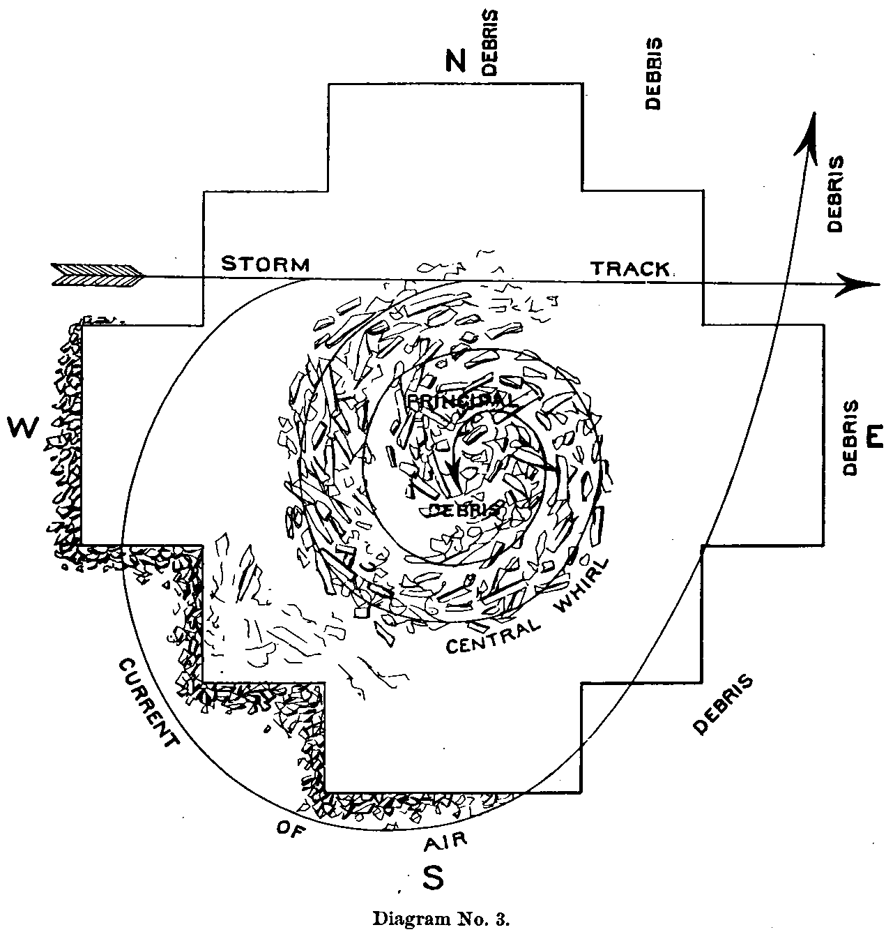 Fifty
rods (251 m) SSW. of these houses stood the house of Mr. James Warden, No. XV, another
banker at Irving. It was vacant at the time. Size 30 by 36 feet (9.1
to 11.0 m), and two stories
high, with a mansard roof. The kitchen attached to the S. end was 22 by 39 feet (6.7
to 11.9 m),
and one story high. The main building was carried bodily from the foundation to
the NNE. a distance of 15 feet (4.6 m), turned bottom side up and torn to pieces, and
the débris scattered along ,the track to the NE. for half a mile (0.805
km). The
kitchen was carried bodily from its foundation 30 feet (9.1
m) to the ESE. and then
dragged about 18 feet (5.5 m) farther, the top crushed over to the E. and the E. side
falling to the ground, where it remained unmoved. The E. half of the roof was
carried E. and NE., for half a mile (0.805 km). An out-house 12 feet (3.7
m) square, and standing
S. of the kitchen 15 feet (4.6 m), was carried bodily 100 feet
(30.5 m) to the E. without being
torn to pieces. An E. and W. board fence, 45 feet (13.7 m)
N. of the house was only blown
down in portions, and that very irregularly, as if caused by the flying débris
from the house. Fifty-one feet (15.5 m) SW. of the kitchen stood the barn and shed,
forming the extreme southern edge of the storm’s path. Both buildings were
entirely unharmed, except a few shingles taken from the roof of the former. A N.
and S. board fence 100 feet (30.5 m) W. of the house had but two panels broken down, and
the outside cellar door over the W. foundation wall was not removed from its
position. Small fruit trees S. and N. of the house, from 30 to 50 feet (9.1
to 15.2 m), were not
the least injured. This building was said to be perhaps the strongest in the
whole town. It was constructed with great care and at considerable expense,
particular attention being paid to the frame and its supports, in view of the
heavy winds common to this region of country [sic] Fifty
rods (251 m) SSW. of these houses stood the house of Mr. James Warden, No. XV, another
banker at Irving. It was vacant at the time. Size 30 by 36 feet (9.1
to 11.0 m), and two stories
high, with a mansard roof. The kitchen attached to the S. end was 22 by 39 feet (6.7
to 11.9 m),
and one story high. The main building was carried bodily from the foundation to
the NNE. a distance of 15 feet (4.6 m), turned bottom side up and torn to pieces, and
the débris scattered along ,the track to the NE. for half a mile (0.805
km). The
kitchen was carried bodily from its foundation 30 feet (9.1
m) to the ESE. and then
dragged about 18 feet (5.5 m) farther, the top crushed over to the E. and the E. side
falling to the ground, where it remained unmoved. The E. half of the roof was
carried E. and NE., for half a mile (0.805 km). An out-house 12 feet (3.7
m) square, and standing
S. of the kitchen 15 feet (4.6 m), was carried bodily 100 feet
(30.5 m) to the E. without being
torn to pieces. An E. and W. board fence, 45 feet (13.7 m)
N. of the house was only blown
down in portions, and that very irregularly, as if caused by the flying débris
from the house. Fifty-one feet (15.5 m) SW. of the kitchen stood the barn and shed,
forming the extreme southern edge of the storm’s path. Both buildings were
entirely unharmed, except a few shingles taken from the roof of the former. A N.
and S. board fence 100 feet (30.5 m) W. of the house had but two panels broken down, and
the outside cellar door over the W. foundation wall was not removed from its
position. Small fruit trees S. and N. of the house, from 30 to 50 feet (9.1
to 15.2 m), were not
the least injured. This building was said to be perhaps the strongest in the
whole town. It was constructed with great care and at considerable expense,
particular attention being paid to the frame and its supports, in view of the
heavy winds common to this region of country [sic]
Directly N. of the storm’s center 35 rods (176 m), stood the railroad company’s elevator, No. XVI, which was the last building destroyed on that side; the depot, 350 feet (106.7 m) still farther N., marked the extreme northern edge of the storm’s path. The elevator was entirely demolished, and the débris carried to the E. across the railroad track. The depot was violently shaken, but not torn down. On the side track which ran along in front of the elevator to the E. stood several loaded freight cars, one directly in front, two on the S. end, and five or six on the N. end. The car in front of the elevator was turned over to the E., those on the S. end to the W., and two of those on the N. end, to the E.; the others remained standing. As the storm crossed the railroad track it narrowed down for about 200 feet (61.0 m), just missing the frail section-house, which stood nearly 600 feet (182.9 m) due E. of PAGE 47 -- TORNADOES OF MAY 29 AND 30, 1879.the elevator. A scantling 6 feet (1.8 m) long and 2 by 4 inches (51 to 102 mm) was carried from the lumber yard N. of the depot, and sent crashing through the N. side of the section-house, falling inside upon the floor. 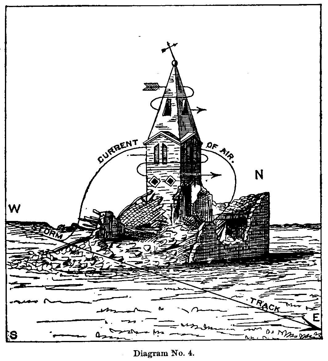 The
storm now passed directly E. over an open square, for about 400 feet (121.9
m), to the
school-house and church, Nos. XVII, XVIII, standing about 275 feet (83.8
m) apart, the
center passing between them. (Diagram No. 3.) The former was a very heavy stone
structure, two and a half stories high, 50 by 30 feet
(15.2 to 9.1 m), with a wing on the north
side 22 by 30 feet (6.7 to 9.1 m), and of the same height. It was entirely demolished, the roof
and walls being whirled into a cone-shaped mass upon the foundation. The walls
were torn down within 2 to 4 feet (0.6 to 1.2 m) of the ground. Heavy corner-stones, 18 by 36
inches (457 to 914 mm), were whirled from their base and thrown into the center of the building.
The roof a [sic] nearly all of the inside timbers lay crushed into splinters in
the center. A portion of the latter were tipped over the walls to the NNE., but
not thereby indicating any general forward movement of the wind, which
throughout bore evidence in the débris of circular action. While the
destruction was going on portions of the walls, S., E., and N. sides, were
thrown outward from 10 to 20 feet (3.0 to 6.1 m), the débris going to the S., ENE., and
N.; but on the W. side, which remained standing 2 feet
(0.6 m) higher than any other
portion, no crumbled remains of the walls were found, the westerly current being
of sufficient force to carry inward and over the foundation. Most of the débris
was carried out to the ENE., in a direction from right to left. The bell, with
frame attached (weighing 220 pounds), was carried from the center of the
building 200 feet (61.0 m) to the NW. Three ladies standing in the church-tower while the
storm was passing saw the school-house when it went down, and stated that, as
the storm struck it, it was enveloped in darkness and whirled around like a top,
carrying the débris about with fearful velocity. Nothing was thrown
outward from the cloud, and as it cleared away a pyramid of shapeless timbers
and stones confirmed their anticipations of the manner of its destruction. The
church went down at the same time, yet the roar of the storm was so great that
the ladies did not know of the terrible destruction they had miraculously
escaped in the demolition of the entire body of the church about them. The
building was of limestone (same as the school-house), 60 by 40 feet (18.3
to 12.2 m), standing E.
and W., with a tower on the SW. corner 60 feet (18.3 m)
high, upon a base 12 feet (3.7 m) square,
the latter continuing the same size for half its height and then tapering to the
spire. (Diagram No. 4.) The wind first struck the building on the W. end,
leaving 18 feet (5.5 m) of the W. wall standing, but destroying the remainder of the
building except the tower, whirling it around the latter by the N. and NE.,
carrying the roof, N. side, and E. end to the SE. and S., crushing to the ground
the S. side. The débris was carried away from the foundation to the SW.
The body of the tower was cracked, about in the center, and so wrenched that the
doors and windows could not be opened. The spire and weather vane were bent to
the SW., and the shingles on the former were torn off only on the W., N., and E.
sides. The body of the spire seemed to be twisted from left to right,
corresponding with the manner in which the débris of the building was
carried. The tower did not form a part of the body of the church, but was built
outside of, and attached to, the SW. corner, extending 12 feet (3.7
m) S. of the S. side
of the church. The W. side of the tower came flush with the W. end of the
church, both presenting a surface of about 1,500 square feet (139.4
sq m) to the wind. The
full force of the current, however, only struck the W. end of the church,
presenting a surface of about 1,200 square feet (111.5 sq
m); but as the wall broke at the
height of 18 feet (5.5 m) above the ground, the impinging area was probably reduced to a
surface of about 400 square feet (37.2 sq m). The
storm now passed directly E. over an open square, for about 400 feet (121.9
m), to the
school-house and church, Nos. XVII, XVIII, standing about 275 feet (83.8
m) apart, the
center passing between them. (Diagram No. 3.) The former was a very heavy stone
structure, two and a half stories high, 50 by 30 feet
(15.2 to 9.1 m), with a wing on the north
side 22 by 30 feet (6.7 to 9.1 m), and of the same height. It was entirely demolished, the roof
and walls being whirled into a cone-shaped mass upon the foundation. The walls
were torn down within 2 to 4 feet (0.6 to 1.2 m) of the ground. Heavy corner-stones, 18 by 36
inches (457 to 914 mm), were whirled from their base and thrown into the center of the building.
The roof a [sic] nearly all of the inside timbers lay crushed into splinters in
the center. A portion of the latter were tipped over the walls to the NNE., but
not thereby indicating any general forward movement of the wind, which
throughout bore evidence in the débris of circular action. While the
destruction was going on portions of the walls, S., E., and N. sides, were
thrown outward from 10 to 20 feet (3.0 to 6.1 m), the débris going to the S., ENE., and
N.; but on the W. side, which remained standing 2 feet
(0.6 m) higher than any other
portion, no crumbled remains of the walls were found, the westerly current being
of sufficient force to carry inward and over the foundation. Most of the débris
was carried out to the ENE., in a direction from right to left. The bell, with
frame attached (weighing 220 pounds), was carried from the center of the
building 200 feet (61.0 m) to the NW. Three ladies standing in the church-tower while the
storm was passing saw the school-house when it went down, and stated that, as
the storm struck it, it was enveloped in darkness and whirled around like a top,
carrying the débris about with fearful velocity. Nothing was thrown
outward from the cloud, and as it cleared away a pyramid of shapeless timbers
and stones confirmed their anticipations of the manner of its destruction. The
church went down at the same time, yet the roar of the storm was so great that
the ladies did not know of the terrible destruction they had miraculously
escaped in the demolition of the entire body of the church about them. The
building was of limestone (same as the school-house), 60 by 40 feet (18.3
to 12.2 m), standing E.
and W., with a tower on the SW. corner 60 feet (18.3 m)
high, upon a base 12 feet (3.7 m) square,
the latter continuing the same size for half its height and then tapering to the
spire. (Diagram No. 4.) The wind first struck the building on the W. end,
leaving 18 feet (5.5 m) of the W. wall standing, but destroying the remainder of the
building except the tower, whirling it around the latter by the N. and NE.,
carrying the roof, N. side, and E. end to the SE. and S., crushing to the ground
the S. side. The débris was carried away from the foundation to the SW.
The body of the tower was cracked, about in the center, and so wrenched that the
doors and windows could not be opened. The spire and weather vane were bent to
the SW., and the shingles on the former were torn off only on the W., N., and E.
sides. The body of the spire seemed to be twisted from left to right,
corresponding with the manner in which the débris of the building was
carried. The tower did not form a part of the body of the church, but was built
outside of, and attached to, the SW. corner, extending 12 feet (3.7
m) S. of the S. side
of the church. The W. side of the tower came flush with the W. end of the
church, both presenting a surface of about 1,500 square feet (139.4
sq m) to the wind. The
full force of the current, however, only struck the W. end of the church,
presenting a surface of about 1,200 square feet (111.5 sq
m); but as the wall broke at the
height of 18 feet (5.5 m) above the ground, the impinging area was probably reduced to a
surface of about 400 square feet (37.2 sq m).
PAGE 48 -- TORNADOES OF MAY 29 AND 30, 1879.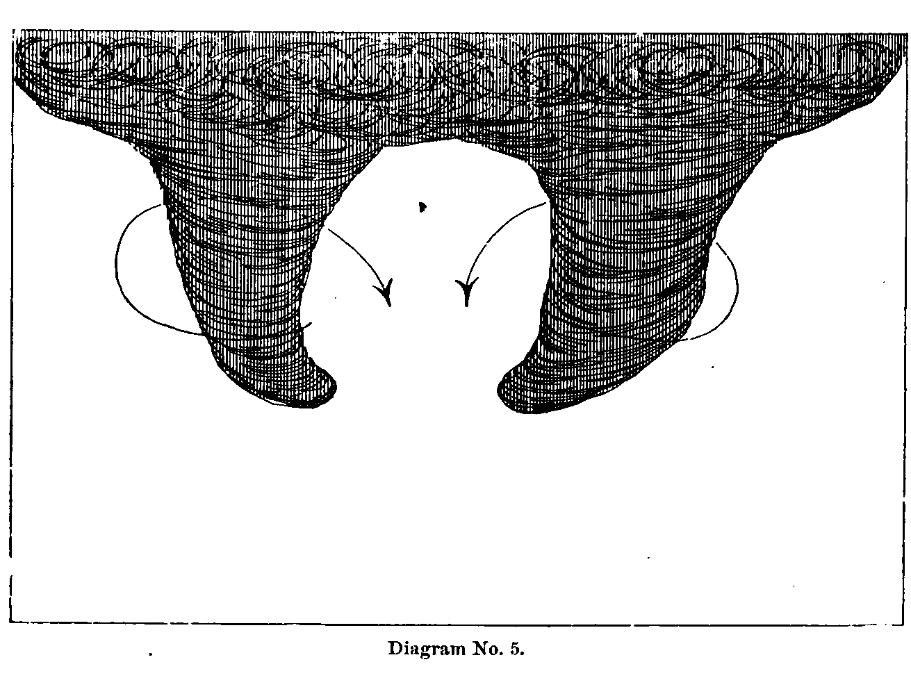 Captain
Armstrong, who witnessed the approach of the storm at this point, stated that
the dark cloud seemed to be formed of two wings, one on the N. and the other on
the S. side, propelling the central body along by an alternate upward and
downward movement towards the ground, first one wing descending and then the
other in an awkward, flopping manner, whirling all objects in opposite
directions inward towards the center. (Diagram No. 5.) This form and movement of
the cloud would certainly seem to make apparent the peculiar destruction at the
church and schoolhouse, both buildings being thrown in towards the center from
the W., by the N. and S. points respectively. Not as in the true tornado was the
débris on the two sides carried inward towards the center by the
continuation of one circularly moving current from the E. by the N. and W. to
the S., but in this instance two currents were acting upon the material from the
sane direction and on opposite sides of the storm’s track, thus reversing the
characteristic action of the tornado. The respective wings of the peculiarly
shaped cloud could not have been over 50 feet (15.2 m)
in diameter, and possibly not
that, especially in the case of the church, where the destruction was confined
to a width of about 40 feet (12.2 m). Captain
Armstrong, who witnessed the approach of the storm at this point, stated that
the dark cloud seemed to be formed of two wings, one on the N. and the other on
the S. side, propelling the central body along by an alternate upward and
downward movement towards the ground, first one wing descending and then the
other in an awkward, flopping manner, whirling all objects in opposite
directions inward towards the center. (Diagram No. 5.) This form and movement of
the cloud would certainly seem to make apparent the peculiar destruction at the
church and schoolhouse, both buildings being thrown in towards the center from
the W., by the N. and S. points respectively. Not as in the true tornado was the
débris on the two sides carried inward towards the center by the
continuation of one circularly moving current from the E. by the N. and W. to
the S., but in this instance two currents were acting upon the material from the
sane direction and on opposite sides of the storm’s track, thus reversing the
characteristic action of the tornado. The respective wings of the peculiarly
shaped cloud could not have been over 50 feet (15.2 m)
in diameter, and possibly not
that, especially in the case of the church, where the destruction was confined
to a width of about 40 feet (12.2 m).
West of the church 160 feet (48.8 m) stood a small tenement house, No. XIX, occupied by a. family, which escaped injury in a very strange but interesting manner. The building was 12 by 16 feet (3.7 to 4.9 m), one and a half stories high and so loosely constructed that several men could have pushed it over without much difficulty. A portion of the bedding, clothing, and furniture were blown out of the doors and windows and the building violently shaken like a dog would take a rat. Directly E. of the church 280 feet (85.3 m) stood the house of Mr. James McCoy, No. XX, 14 by 20 feet (4.3 to 6.1 m), and one story high. It was lifted from the ground and carried 150 feet (45.7 m) to the NE., breaking to pieces, when the débris was scattered to the E. and SE. The storm now spread out to the S. over the path of that traversed by No. I, and followed it for half a mile (0.805 km), but extending its path of destruction several hundred feet farther to the N. After leaving Mr. McCoy’s the storm passed over vacant lots for about one-fourth of a mile (0.402 km) to the house of Mr. Griffin, No. XXI, which it carried entirely away, throwing the débris to the SE., S., and SW. Along a board fence 25 feet (7.6 m) N. of the house, eight posts were pulled out of the ground from a depth of 2½ feet (0.76 m) and the remainder were stripped of the boards. Posts on the E. and W. side of the house were only divested of boards. The house of Mr. W. J. Williams, No. XXII, 6 rods (30 m) directly E. of Mr. Griffin’s, was next destroyed. The main part running E. and W. was of stone, and the kitchen attached to the S. side was of wood. The NE. corner of the former was first struck by the wind, crushing in the E. end and then whirling the roof and walls around to the SW. and SE. The kitchen, in which were gathered several families, remained unharmed. Mrs. Williams, who, in search of her child, passed from the kitchen into the main part as the crash came, was found dead with the baby in her arms, the latter still alive and apparently uninjured. The picket fence W. of the house remained standing, except about 18 feet (5.5 m) opposite the SW. corner of the house, which was partially torn down by the falling timbers. Out of a group of four shade trees standing at the N. side of the house only one, and that the. smallest, was broken off, its top pointing to the SW. The others were partially stripped of their foliage, but not broken. On the S. side of the house four trees were uprooted, PAGE 49 -- TORNADOES OF MAY 29 AND 30, 1879.three of them carried several rods to the SE., and one weighing about 600 pounds, with roots attached, was found three-fourths of a mile (1.207 km) E. of the house. Trees standing in the corner between the kitchen on the E. and the main building on the N. were not damaged, except by those portions of the débris which fell against their trunks. One of the number rising considerably above its companions had its top badly whipped and broken. The destructive current here must have been very narrow, for the kitchen stood barely 30 feet (9.1 m) S. of the. N. corner of the main part, and the trees and fence on the N. side of the house 15 to 18 feet (4.6 to 5.5 m) distant were not destroyed. The full force of the current could not have been over 45 feet (13.7 m) wide. The house of Mr. M. L. Cook, No. XXIII, a very small and hastily built structure, 110 feet (33.5 m) NE. of Mr. Williams’s, was entirely enveloped in dark smoke and violently shaken by a whirling current going from left to right, but it was not overturned. The current seemed to be still stronger 350 feet (106.7 m) to the NNE. of Mr. Cook’s, at the house of Steven A. Bowdish, No. XXV, size 18 fry 38 feet (5.5 to 11.6 m), and two stories high, which was carried bodily to the SE. a distance of 40 feet (12.2 m). The E. end struck the ground and the building was then turned over, torn to pieces, and the fragments scattered out upon the prairie to the E. and SE., three-quarters of a mile (1.207 km). Some portions were found on the high bluffs across the Big Blue, 3 miles (4.828 km) to the E. At the same time the small barn of Mr. J. C. Ward, No. XXIV, standing 80 feet (24.4 m) SW. of Mr. Bowdish’s, was carried away to the SE. Mr. Ward’s house, No. XXVI, 100 feet (30.5 m) N. of his barn, marked the northern edge of the storm’s path in this section of the city. The house was severely shaken and battered with flying débris but not seriously injured. The storm has now reached the eastern skirts of the town and completed the last destruction within its limits. It left the track of No. I and passed with a much contracted form to the ESE. through the third natural gateway out of the plain upon which the town of Irving rests. For a distance of 2 miles (3.219 km) over the naked fiats it passed (almost entirely above the ground) filled with flying débris and accompanied with an awful roar. When it crossed the Big Blue about 60 rods (302 m) S. of the course of the storm No. I, and near the month of Game Fork Creek, it cut a swath about 20 rods (101 m) wide through the heavy timber for a distance of half a mile (0.805 km). The storm now struck the high prairie between the houses of Mrs. Cook and Mr. Boyd, about 1 mile (1.609 km) apart, but causing no damage to either. Here the cloud broke up and all traces of its peculiar shape and whirling motion gradually disappeared, but a heavy storm of rain and bail continued across the prairie for several miles. Mr. Charles Preston, who was watching the disappearing cloud from his house in Irving, stated that upon reaching the high prairie it immediately changed its dense, dark color to a lighter gray, when its strange form vanished and the clouds scattered in several directions. People living 3 or 4 miles (4.828 to 6.437 km) E. of this point knew nothing of the second storm, but experienced the effects of the first Before proceeding with storm No. I, I will present several statements of persons who witnessed the approach of the two storms, also other matters of interest, particularly the relative time of appearance, &c. [sic] Storm No. I crossed the railroad track after leaving Mr. Gallops’s, at 5.35 [sic] p. m., railroad time, or 5.14 [sic] p. m., local time, according to the statements of several very reliable persons. The passenger train west, on the Central Branch of the Union Pacific was due at 5.25 [sic] p. m., Jefferson City time, which is 21 minutes faster than local time. The train stopped at the road-crossing before reaching the depot, and about in line with the center of the approaching storm, in doubt whether to proceed or not, as the terrible cloud could be seen some distance to the SW. coming down the creek. No one knew precisely how long the train waited, but thought it must have been five or six minutes. By the time the cloud reached Mr. Ship’s house, 1⅞ miles (3.018 km) SW. of the railroad track, the engineer and conductor doubtless felt more certain about the course it would pursue, as they proceeded rather slowly to the depot, a distance of 80 rods (402 m). The train had hardly arrived ere [sic] the storm cloud passed with terrible fury over the very spot it had vacated not two minutes before. Based upon the time above furnished, the progressive velocity of storm No. I was about 30 miles per hour (48 kph). When storm No. II reached the depot the shaking of the building stopped the large regulator at exactly 6.45 [sic] p. m., and the agent’s clock stopped at his house at 6.40 [sic] p. m. These clocks still remained undisturbed as the storm had left them, leaving no doubt as to the precision of the time. Storm No. I reached the railroad track at 5.35 [sic] p. m., and No. II at 6.45 [sic] p. m., but at 7 [sic] PAGE 50 -- TORNADOES OF MAY 29 AND 30, 1879.a point 80 rods (402 m) to the NW., a difference in time of one hour and ten minutes. The relative width of the two storms are given as follows: When storm No. I was at Mr. Ship’s it measured half a mile (0.805 km) from E to W., but narrowed down to less than 40 rods (201 m) at Mr. Gallops’s. After leaving the latter’s house the cloud lifted from the ground, descending at Captain Armstrong’s, where it widened out to a quarter of a mile (0.402 km), again contracting until it reached the riverbeyond [sic]. Storm No. II, when it reached Mr. Preston’s farm, was about 1½ miles (2.414 km) in width, taking up a large portion of the valley. At the edge of the town, near Mr. Johnson’s, its width was 1 mile (1.609 km). At Messrs. Walker’s and Kenney’s it was three-quarters of a mile (1.207 km). Between the depot on the N., and the barn of Mr. Warden, on the S., it had narrowed down to 125 rods (629 m); at the church and school-house to 1,360 feet (414.5 m). At Messrs. Griffin’s and Williams’s the storm widened out again to something over half a mile (0.805 km), contracting again after passing to the SE., so that at the river its path was about 400 feet (121.9 m). As to the relative velocities of the two storms through the city, nothing can be said of greater importance than to repeat the general and harmonious statement that No. I moved most rapidly. Several reliable persons stated that it passed through the builded portion of the town, a distance of 1¼ miles (2.012 km), in one and one-half -minutes; others said one and two minutes. In regard to storm No. II, the time is put at from two to three and one-half minutes. The following are portions of letters and verbal statements received concerning the peculiarities of the two storms. Mr. D. S. Giles, proprietor of the Irving Hotel, states that upon May 30, while returning from his farm in the country at 3.30 [sic] p. m., he experienced a moderate rain with a southerly wind. No rain before during the day, which had been quite sultry, with a continued alternation of clear and cloudy sky [sic] During the forenoon, while upon the high prairie, he felt an alternation of hot and cold currents of air in a manner which seemed very unusual. Soon after noon the clouds began to gather quite thickly in the W. and S., and succeeding the first rain the wind changed to the SW., W., and back again to the S., followed during the last wind by rain and a small quantity of hail. After the hail had nearly ceased, the strange, funnel-shaped cloud appeared in sight about 5 miles (8.047 km) to the S. The upper part of the cloud appeared to be about the size of an ordinary barrel. It stood out clear and well-defined against a background of comparatively clear sky. As the cloud drew nearer and passed down Game Fork Creek, scud-like clouds from the N., S., and W., which shortly before seemed to be agitated by an unseen force, now dashed into the lower portion of the funnel, then up through its vortex and out at the top. Immediately after the cloud had passed through the city, perfect sheets of rain fell with a strong S. wind, the latter of sufficient force to nearly throw people from their feet. After the hardest precipitation ceased, the sun came out very beautifully for about fifteen minutes, but it was still considerably cloudy in the NNW. and SW., looking very much as if the entire storm had not passed. In about forty minutes an exceedingly dense black cloud appeared in the NW., 8 or 10 miles (12.875 to 11.609 km) distant. Its darkness became intense with fearful rapidity, sending terror into the hearts of the bravest. People were trying to collect their wits and accustom themselves to the great calamity already befallen them, but upon the advent of this second monster all hope fled and the wildest terror reigned supreme. Many thought the millennium was surely at hand. The cloud was not ragged, irregular, or funnel-shaped, but presented a square and perpendicular front, moving steadily forward like the broadside of an immense mountain a mile (1.609 km) in width, its summit lost in the impenetrable darkness above. The wind at Irving was from the SW., very strong, attended with lighter clouds of smoky appearance. When these two sets of clouds drew together, no funnel-shaped column was seen to descend, but there followed great commotion among them. The NW. cloud moved forward more rapidly, and for the first time the awful roar broke upon the ears of the terror-stricken people like the belching and bellowing of trains of artillery. The noise throughout the course of storm No. II far exceeded the first storm, although at the time the rumbling of No. I was considered deafening. Mr. William Wells stated: "I live 6 miles (9.656 km) SE. of Irving; was in a tornado on the plains of Nebraska in 1860. As soon as I saw this one, I said to my wife, ‘It will tear everything to pieces that it touches.’ At first it seemed to stand still, but soon hurried by. I could gee it for a distance of from 25 to 30 miles (40.234 to 48.280 km). It took three quarters of an hour to travel that distance." This communication refers to storm No. 1 [sic]. Mr. W. H. Cheesman, of Irving, stated that he watched the second storm while forming. The cloud presented a heavy, solid, nearly square front, reaching PAGE 51 -- TORNADOES OF MAY 29 AND 30, 1879.from the earth to the sky. Its form and movement were awe-inspiring, and quickly impressed one with the idea of inconceivable power and majesty. With its approach there came from the SW. hail and rain, the former small, but in large quantities. When the two clouds came together the precipitation ceased, and the NW. cloud moved rapidly forward (but not in funnel shape) with the most indescribable roar. After it had passed the city there followed from the W. the heaviest rain of the season (without hail), succeeded by a most painfully cold NW. wind, necessitating overcoats, and causing the wounded and dying to shiver and moan from its penetrating effects. No lightning was seen with either storm cloud. Dr. Chase, physician at Irving, stated that his attention was particularly directed to the shape and direction of motion of storm No. 1 [sic]. The cloud tapered from top to bottom like an elephant’s trunk and whirled invariably from right to left. He thought the wind during most of the day was from the E. and SE., attended with rather cool and pleasant weather until an hour or two before the first storm, when the air became very oppressive. The first rain and bail came with an ENE. wind about twenty minutes before the funnel came in sight. This statement does not really contradict that of Mr. Giles, who was stationed about 4 miles (6.437 km) SW. of the city upon the high prairie, while Dr. Chase was in the extreme northeastern portion of the town where a current of air would be experienced moving toward the approaching storm. The hail was very large but scattering. After the funnel had passed over the bluffs to the E. an exceedingly heavy rain followed for about ten minutes, stopping as soon as the sun came out (others say it rained while the sun was shining). In about thirty minutes an intensely black cloud filled the western horizon, piled up layer upon layer in the most unusual manner, apparently from the earth to sky. As the cloud drew near to the city another very hard rain with some hail fell. While it was passing through the city a slight precipitation was experienced on the extreme edges of the cloud to the N. and S. About in the center of the black cloud a spot apparently 15 or 20 feet (4.6 to 6.1 m) in diameter seemed much blacker than its surroundings. Within this small area a whirling motion was discerned, but no funnel-shaped mass was seen to descend such as witnessed in storm No. I. No thunder or lightning attended either cloud while within the range of vision, yet both were accompanied by rain and hail though not of unusual intensity. Mr. Pumphrey, 3 miles (4.828 km) due S. of Irving, upon the high bluffs overlooking the town, felt no influence of the storm at his place, but saw both of the clouds with equal clearness during their passage. There was a slight fall of hail at his house but none farther S. Mr. Morgan, 2½ miles (4.023 km) N. of Irving, experienced quite a severe wind from SW. and W., unroofing a two-story log house and blowing down a few small trees. Hail fell in quite large quantities and extended about 1½ miles (2.414 km) farther N. At the house of Mr. Strange, about 5 miles (8.047 km) N. of Irving, there was no strong wind or hail. Taking into consideration these statements, we find the width of the hail storm to have been about 7 miles (11.265 km) in this vicinity and 1 mile (1.609 km) wider to the N. of Irving than to the S. The path of destructive winds was fully 1½ miles (2.414 km) wider on the left than on the right side of the area of destruction through the town, caused by the direction taken and the large proportions of the second storm, whose center was at times one-fourth to one-half mile (0.402 to 0.805 km) N. of No. I. Mr. James Patterson, one of the most self-possessed men in the town during the passage of the storms, stated that while they were moving through the village there was experienced on their extreme edges an upward pressure, which acted so powerfully as to apparently reduce a man’s weight about two-thirds. Small articles of every kind were observed rising from the ground from localities where no strong wind was felt, and finally drawn into the tornado cloud. It was necessary to hold your hat on, even when you felt no pressure against the side of your body. Shavings, straws, and other light objects would ascend in a straight line for a considerable distance and then all at once dart with lightning rapidity downward to the base of the funnel cloud, then upward through its vortex and out at the top. Nothing was seen to descend from the top through the funnel, but always ascended from the base, flying out in every direction from the top. In a similar manner did the light scud clouds, floating naturally about in the surrounding atmosphere until they came within the compass of the powerful suction, shoot downward on the outside of the funnel with inconceivable velocity, and then upward through the vortex. After the storm passed a downward pressure was directly experienced to such a degree that the rim of a slouch hat would fall down over the eyes, and small limbs upon the trees were noticed to bend downward. These PAGE 52 -- TORNADOES OF MAY 29 AND 30, 1979.sensations were experienced by several other persons, but very few were out of their cellars and "dug-outs" to make these observations. Immediately after storm No. I passed, rain seemed to come in sheets on either side of the track, as if poured over from the edges of an overhanging cloud. It did not rain in the wake of the storm for soma two minutes, until the clouds could gather, as it were, from each side. Mr. D. T. Ward, of Irving, stated in a letter of July 2, in reply to several requests I had made about the distance heavy objects were carried, &c., as follows: The tool-chest of Mr. J. H. Case, weighing 320 pounds with contents, stood by the S. side of his house (the latter W. of the storm center). It had remained upon the ground long enough to sink itself several inches into the soil. While the family were watching the approaching storm, and before its effects were felt upon the house, the tool-chest was observed to rise from the ground about 2 feet (0.6 m) and move quite evenly to the SW. toward the storm, a distance of 35 feet (10.7 m), where it was deposited without disturbing the tools. A hand-car situated on the side track near the elevator was totally wrecked; two of the wheels with axle attached were carried 350 feet (106.7 m) to the E. and nearly twisted off. Mr. Frank Seaton, who was in Mr. Sabin’s house at the time of the storm, was carried out of the top of the building after the roof was blown off and found 320 yards (293 m) to the E. He and others who saw him say that he was carried at least 40 feet (12.2 m) before landing for the first time; was taken up again but not so high, and partly carried and rolled about 100 yards (91 m), after which he became unconscious, and was lost sight of by those who were watching him. From the house of Mr. Gallops a piece of cottonwood window-frame was carried 100 yards (91 m) to the E. and imbedded so firmly in an elm log that it could not be withdrawn. A great many portions of broken lumber-wagons and carriages had not been found up to the date of this letter, although miles of territory were traversed in their search. Heavy tires were found broken and twisted or straightened out like bar iron. North of Frankfort on the West Fork of the Vermillion River, where the storm crossed, a large stone, weighing from 600 to 800 pounds (partially raised out of the quarry on the W. side of the bluffs), was carried up to the top, a distance of 30 feet (9.1 m), and then rolled over the prairie for 350 feet (106.7 m).  Mr.
Ward also stated that there were several instances where people were carried out
at the tops of the houses after the roof’s went off and before the building
went to pieces; also cases where the sides and roof went together over the heads
of the unfortunate inmates, who were left upon the ground floor where they
received ugly scalp or back wounds. Mrs. Griffin’s black-velvet bonnet with
ostrich feathers was found 3 miles (4.828 km) E. of the city upon the high prairie above
the bluffs, torn, wet, and dirty. Mr. Keeney’s pants, with pocketbook
containing $1.60 and a note upon one of the business firms in the town, was
found 2½ miles (4.023 km) to the SE., on the farm of Mr. Day. A new rag carpet was taken
from the floor of Mr. Keeney’s house, and carried nearly half a mile (0.805
km) to the
SE. without tearing a seam. It was securely tacked down about the entire room. A
window blind, recognized by its color, was carried from Captain Armstrong’s
house 5 miles (8.047 km) to the NE. Letters and papers were also found in the same
direction, a distance of 7 miles (11.265 km). A window-weight of 5 pounds was carried from
the house 40 rods (201 m) to the NE. and imbedded in the ground. Among the most
wonderful freaks of the first storm was that displayed in the transportation of
a cow belonging to Mr. Jasper Martin, whose house stood on the eastern edge of
the storm’s path, near Game Fork Creek. (Diagram No. 6.) By a very careful
consideration of the circumstances attending the probable transportation of the
cow, it was found that she was picketed near his house before the storm, but
after it subsided she was noticed walking towards Mr. Casey’s house on the N.
side of the creek, having a portion of the lariat rope still upon her horns and
her body in a dreadfully muddy condition. On tracing her track backwards about
100 rods (503 m) down the creek to the NW. a point was reached where the tracks
terminated in a fall imprint of the beast in the plastic mud. From this spot the
distance was measured back to the picket pin on the opposite side of the creek,
covering nearly 140 rods (704 m). The growth of timber along the creek, averaging 30 Mr.
Ward also stated that there were several instances where people were carried out
at the tops of the houses after the roof’s went off and before the building
went to pieces; also cases where the sides and roof went together over the heads
of the unfortunate inmates, who were left upon the ground floor where they
received ugly scalp or back wounds. Mrs. Griffin’s black-velvet bonnet with
ostrich feathers was found 3 miles (4.828 km) E. of the city upon the high prairie above
the bluffs, torn, wet, and dirty. Mr. Keeney’s pants, with pocketbook
containing $1.60 and a note upon one of the business firms in the town, was
found 2½ miles (4.023 km) to the SE., on the farm of Mr. Day. A new rag carpet was taken
from the floor of Mr. Keeney’s house, and carried nearly half a mile (0.805
km) to the
SE. without tearing a seam. It was securely tacked down about the entire room. A
window blind, recognized by its color, was carried from Captain Armstrong’s
house 5 miles (8.047 km) to the NE. Letters and papers were also found in the same
direction, a distance of 7 miles (11.265 km). A window-weight of 5 pounds was carried from
the house 40 rods (201 m) to the NE. and imbedded in the ground. Among the most
wonderful freaks of the first storm was that displayed in the transportation of
a cow belonging to Mr. Jasper Martin, whose house stood on the eastern edge of
the storm’s path, near Game Fork Creek. (Diagram No. 6.) By a very careful
consideration of the circumstances attending the probable transportation of the
cow, it was found that she was picketed near his house before the storm, but
after it subsided she was noticed walking towards Mr. Casey’s house on the N.
side of the creek, having a portion of the lariat rope still upon her horns and
her body in a dreadfully muddy condition. On tracing her track backwards about
100 rods (503 m) down the creek to the NW. a point was reached where the tracks
terminated in a fall imprint of the beast in the plastic mud. From this spot the
distance was measured back to the picket pin on the opposite side of the creek,
covering nearly 140 rods (704 m). The growth of timber along the creek, averaging 30
PAGE 53 -- TORNADOES OF MAY 29 AND 30, 1879.to 40 rods (151 to 201 m) in width, was very heavy and almost impenetrable, making it impossible for the caw to have passed through it alive, so that the most rational conclusion to come to was, that she was carried over the tops of the trees, a height of from 30 to 60 feet (9.1 to 18.3 m) (although perhaps not as high when the wind was blowing, bending down their tops), and landed in a cornfield, three-eighths of a mile (0.604 km) to the NW. Mr. Charles Preston stated, in a letter written at my request, that he was
watching the second storm approach, from the roof of his seminary, about 6 p. m.
Saw the storm, 10 or 12 miles (16.093 to 19.312 km)
to the PAGE 54 -- TORNADOES OF MAY 29 AND 30, 1879.the clouds, especially in the afternoon, which now, instead of disappearing as before, began to thicken and concentrate in the SW. and NW. in a most threatening manner. The peculiar approach of this remarkable cloud, its strange manifestations, and its still stranger destructive effects, when considered in connection with the invariable accompaniments of the true tornado, will, I think, define its isolated position. Its incipient stages were attended with some of the characteristic attributes, but it lost them before its work commenced, resulting possibly from the peculiar condition of counteracting currents then violently confused by contemporary storms. This closes the analysis of the two storms at Irving, and we now resume our examination of storm No. I. After reaching the high prairie beyond the Big Blue it passed to the NE. over the gently undulating surface of a region very thinly inhabited, a distance of 3½ miles (5.633 km) to the house of Milo Wicks, on Corndodger Creek, a small stream running from NW. to SE. and emptying into the Black Vermillion. His building stood on the very edge of the stream, about the center of the storm’s path, and 50 or 60 feet (15.2 to 18.3 m), on a gradual descent, below the surrounding level. House, barn, corn-crib, and farming implements were entirely destroyed and scattered over the prairie in the direction of the storm’s course. The house of Mr. Riley Somers, 10 rods (50 m) to the S. of the former residence, had the NW. corner of the roof taken off, but no other damage resulted. The cloud after crossing the intervening valley raised up a gradual ascent of 60 feet (18.3 m) to the high prairie, where it moved above the ground, for a distance of 2 miles (3.219 km), when it reached a little ravine running from NW. to SE., like many others it had already passed over. Up this ravine the cloud moved a distance of 50 rods (251 m), demolishing the small house of Mr. Earl, drawing it inward to the storm’s center and carrying the débris to the SW. and SE. Rising to the high prairie again, and passing on 3½ miles (5.633 km) to the NE., it simply overturned the small house of Mr. Goodnight. Mr. David Webb’s house, a few rods to the W., was moved from its foundation to the W., and the kitchen on the S. end turned completely over. For a distance of 1½ miles (2.414 km) to the NE, the storm passed over a portion of the prairie which gradually descends to the backs of Johnson’s Branch, a small stream running SE. into the Black Vermillion. Under the western bank and about 5 rods (25 m) from the creek stood the small dwelling of Mr. Roper, which was entirely swept away, hardly leaving a vestige of the foundation. Fifteen rods (75 m) to the NW., and a little higher than Mr. Roper’s, stood the house of Mr. Caywood, on the W. side of the storm’s center, which was thrown over and crushed in falling, but the débris was not carried away. On the opposite side of the track, and 10 rods (50 m) SE. of the storm’s center, the house of Mr. Fitch was turned over and torn to pieces, the débris being carried to the NE. and N. His young son was carried over the tree tops and the creek, a distance of a quarter of a mile (0.402 km) to the NW., and landed unhurt. In crossing the creek the storm spread out to about 1 mile (1.609 km) in width, destroying six small houses, scattered farther down the stream. The house of Mr. William Trosper, which stood as near the storm’s center as that of Mr. Caywood’s, but about 40 feet (12.2 m) higher, was not touched. Rising upon the high prairie again, and pursuing its course to the NE., the storm threw over a small building, but not otherwise damaging it. The storm now reached the West Fork of the Vermillion, 3½ miles (5.633 km) NW. of Frankfort, just above the mouth of Snipe Creek, where it destroyed the houses of Messrs. Fox, Ceasen, and Vaughn. The former was situated on the E. side of the storm’s center in the creek bottom, where it was torn to pieces, and most of the débris carried to the N. and NW. The two latter were on the W. side of the storm’s center, and the débris carried to the W. and SW. Mr. Vaughn’s chickens were completely stripped of their feathers, some living through the ordeal, but most of them were killed and scattered over the prairie. Just before the tornado passed to the northward, a heavy storm of rain and hail passed over the city of Frankfort from the SW., damaging several small buildings, but committing nothing serious. No influence was felt from the tornado cloud, for at the place of its passage over the West Fork of the Vermillion, the path of destructive winds was not over 1½ miles (2.414 km) wide. The storm now started up Snipe Creek through Rock Township to the NNE., sometimes keeping close to the creek, and then again bearing more to the N. on the high land, between the West Fork of the Vermillion and the two branches of Snipe Creek. The storm path over this section spread out to an unusual width, destroying houses in some portions of the track over 2½ miles (4.023 km) apart, E. and W. Perhaps the most immediate cause for the storm thus embracing a larger extent of country was due to the fact that there were three large creeks running almost in the same direction to the NNE. within PAGE 55 -- TORNADOES OF MAY 29 AND 30, 1879. less
than 1 mile (1.609 km) of each other, and all branching out from the same locality, viz,
where the storm crossed the Vermillion. The ground between these creeks was not
what you might call high prairie, as it was generally to a considerable degree
below the level bounding the creeks to the E. and W. The first house encountered
upon Snipe Creek was that of Mr. Henry Johnson, about 50 rods (251
m) E. of the storm’s
center. The cloud was now moving northeastward one-quarter mile (0.402
km) NW. of the
creek. The building was entirely demolished, and the débris carried to
the N. and NW. Mrs. Johnson was killed by the falling timbers. Mr. Waxtel’s
house, 100 rods (503 m) to the NE., was partially destroyed and the débris carried
more to the N. The residence of Mr. James Downs, one-quarter of a mile (0.402
km) to the
NE. but on higher ground, and still on the E. side of the storm’s center, was
utterly swept away, and Mr. and Mrs. Downs carried out upon the prairie to the
NNE. several hundred yards, killing both. The buildings of Mr. Grove, 35 rods (176
m) ENE., of Mr. Downs’s, and on the western bank of the creek in the timber, were
dreadfully demolished, and the débris scattered among the trees, and
also to the N. and NW. over the bottoms. Mr. Grove was carried to the N. some
distance from the house and killed. The house of Mr. Colwell, 70 rods (352
m) to the N.,
was destroyed, and the débris carried to the NW. The houses of Messrs.
Lane and ferry, the former to the N. 50 rods (251 m), and the latter nearly half a mile
(0.805 km) to the W., but still E. of the storm’s center, were carried to the NE. One
half mile (0.805 km) directly N., the houses of Messrs. Vite and Conors were carried to the
N. and NW. The storm had up to this point confined its destruction to the
immediate boundaries of Snipe Creek, its center passing from one-quarter to
one-half mile (0.402 to 0.805 km) W. of it, along the bottoms, over sections 17 and 18, township 3
N., range 9 E. It now spread out to the West Fork of the Vermillion, about 1 mile (1.609 km)
farther, but with much diminished energy, which is shown by the fact that
only the roofs were taken from the houses of Messrs. Cramer, Walker, and Foley
in that vicinity. Between these houses and those of Charles and George Kieper
and William Cassidy, destroyed within the storm’s center, there stretches a
broad tract of open prairie 1¼ miles (2.012 km) in width, where no doubt the wind blew
with great violence, but there was no material upon which to demonstrate its
powerful force, and thereby leave evidence of its path. The barn of Mr. Cassidy,
E. of the house, stood directly in the storm’s center. The main part was
carried to the N., torn to pieces, and scattered along the track for a mile (1.609
km). The
shed was carried to the NW. and converted into kindling wood. The platform of a
mowing-machine, together with a hay-rack, were lying in the barn quite near to
each other. The former was carried three-quarters of a mile
(1.207 km) to the W., and the
latter half a mile (0.805 km) to the E. (Diagram No. 8.) The horse, which stood abort 200
feet (61.0 m) W. of the barn, was torn to pieces and the débris carried to the
WSW. and SE. E. of the houses occupied by Kieper brothers, and across Snipe
Creek 1¼ miles (2.012 km), the house of Mr. James Bowman was destroyed and several of the
family badly bruised. The destructive winds at this point extended 2½ miles (4.023
km) E.
of the storm’s center and 1½ miles (2.414 km) W. This width still continued for one tier
of sections farther N., but with somewhat diminished energy. less
than 1 mile (1.609 km) of each other, and all branching out from the same locality, viz,
where the storm crossed the Vermillion. The ground between these creeks was not
what you might call high prairie, as it was generally to a considerable degree
below the level bounding the creeks to the E. and W. The first house encountered
upon Snipe Creek was that of Mr. Henry Johnson, about 50 rods (251
m) E. of the storm’s
center. The cloud was now moving northeastward one-quarter mile (0.402
km) NW. of the
creek. The building was entirely demolished, and the débris carried to
the N. and NW. Mrs. Johnson was killed by the falling timbers. Mr. Waxtel’s
house, 100 rods (503 m) to the NE., was partially destroyed and the débris carried
more to the N. The residence of Mr. James Downs, one-quarter of a mile (0.402
km) to the
NE. but on higher ground, and still on the E. side of the storm’s center, was
utterly swept away, and Mr. and Mrs. Downs carried out upon the prairie to the
NNE. several hundred yards, killing both. The buildings of Mr. Grove, 35 rods (176
m) ENE., of Mr. Downs’s, and on the western bank of the creek in the timber, were
dreadfully demolished, and the débris scattered among the trees, and
also to the N. and NW. over the bottoms. Mr. Grove was carried to the N. some
distance from the house and killed. The house of Mr. Colwell, 70 rods (352
m) to the N.,
was destroyed, and the débris carried to the NW. The houses of Messrs.
Lane and ferry, the former to the N. 50 rods (251 m), and the latter nearly half a mile
(0.805 km) to the W., but still E. of the storm’s center, were carried to the NE. One
half mile (0.805 km) directly N., the houses of Messrs. Vite and Conors were carried to the
N. and NW. The storm had up to this point confined its destruction to the
immediate boundaries of Snipe Creek, its center passing from one-quarter to
one-half mile (0.402 to 0.805 km) W. of it, along the bottoms, over sections 17 and 18, township 3
N., range 9 E. It now spread out to the West Fork of the Vermillion, about 1 mile (1.609 km)
farther, but with much diminished energy, which is shown by the fact that
only the roofs were taken from the houses of Messrs. Cramer, Walker, and Foley
in that vicinity. Between these houses and those of Charles and George Kieper
and William Cassidy, destroyed within the storm’s center, there stretches a
broad tract of open prairie 1¼ miles (2.012 km) in width, where no doubt the wind blew
with great violence, but there was no material upon which to demonstrate its
powerful force, and thereby leave evidence of its path. The barn of Mr. Cassidy,
E. of the house, stood directly in the storm’s center. The main part was
carried to the N., torn to pieces, and scattered along the track for a mile (1.609
km). The
shed was carried to the NW. and converted into kindling wood. The platform of a
mowing-machine, together with a hay-rack, were lying in the barn quite near to
each other. The former was carried three-quarters of a mile
(1.207 km) to the W., and the
latter half a mile (0.805 km) to the E. (Diagram No. 8.) The horse, which stood abort 200
feet (61.0 m) W. of the barn, was torn to pieces and the débris carried to the
WSW. and SE. E. of the houses occupied by Kieper brothers, and across Snipe
Creek 1¼ miles (2.012 km), the house of Mr. James Bowman was destroyed and several of the
family badly bruised. The destructive winds at this point extended 2½ miles (4.023
km) E.
of the storm’s center and 1½ miles (2.414 km) W. This width still continued for one tier
of sections farther N., but with somewhat diminished energy.
In sections 9 and 10, along Snipe Creek, the following destructions occurred: The house of Mr. Schults, E. of the creek, in section 9, was unroofed and the débris carried to the NW. Mr. A. J. McGee’s house, in section 9, half a mile (0.805 km) farther N., and Mr. Henry Boatman’s, in section 10, one quarter of a mile (0.402 km) to the E., were entirely destroyed, and the ruins carried to the NE. and N. and NW. In the NW. corner of section 8, and W. of the storm’s center, Mr. Buffon’s house was destroyed, and 1 mile (1.609 km) farther W., in section 7, the houses of Messrs. Satterfield and S. S. Martin were only unroofed. In the SW. corner of section 6, the stable of William Life was destroyed. In passing 1 mile (1.609 km) farther to the N. the path of destruction diminished nearly as much in width. Leaving entirely the wide bottoms of the Vermillion, in order to preserve its NE. course, it confined its destruction hereafter to the east and west branches of Snipe Creek, and finally to the east branch alone, which ran more directly NE. On the west branch of Snipe Creek, the houses of Messrs. Bulkley and PAGE 56 -- TORNADOES OF MAY 29 AND 30, 1879.White, standing E. of the storm’s center, were demolished and the débris carried to the NE., N., and NW. The district school-house, 3 miles (4.828 km) S. and 1 mile (1.609 km) E. of Beattie, standing upon the high prairie between the east and west branches of the creek and E. of the storm’s center, was a complete wreck, hardly a vestige of the building remaining near the foundation. The débris was scattered to the NE. and N.  One
mile (1.609 km) S. and half a mile (0.805
km) E. of Beattie the storm reached the house of Mr. Leroy
Sample, standing W. of the storm’s center about 100 yards (91
m), on a rise of ground
descending westward to the west branch of Snipe Creek. (Diagram No. 9.) The
building was taken up bodily, except the ground floor, and carried to the SE. 5
rods (25 m), twisted to pieces, and the débris carried to the E., NE., and N.,
covering nearly a 40-acre (16.2 hectares) field. Three members of the family, who were left upon
the floor while the body of the house was carried over their heads, were
considerably injured. Mr. Sample, jr. [sic], was carried several rods to the SW.
and nearly stripped of his clothing. A stable, 20 rods
(101 m) SW. of the house, was
blown to pieces and the débris carried to the SE. A round 5-pound weight
was carried from the house 40 rods (201 m) to the SE. One of the house sills, 6 by 8
inches (152 to 203 mm) and 10 feet (3.0
m) long, was carried 120 rods (604 m)
to the SE. Two sulky cultivators,
weighing several hundred pounds each, and standing 5 rods (25
m) NE. of the barn, were
carried into the creek 20 rods (101 m) to the SW. A wagon box, 30 feet
(9.1 m) SE. of the barn,
was carried 40 rods (201 m) to the SE. and blown to pieces. A spring wagon, standing
close by the house, was torn to pieces, and not a spoke left in any of the hubs,
some of which were, found over a mile (1.609 km) to the E. A tin-type picture, 6 by 8
inches (152 to 203 mm), was blown out of its frame which hung up in the house, carried 1½ miles
(2.414 km) to the NE., and found with one corner driven into an elm tree to the depth of
half an inch (12.7 mm). Mr. Sample stated that the weather had been very warm during the
day, with rather a brisk southerly wind, which had been the prevailing direction
for some time past. At shout 3 p. m. a gentle rain set in with a SW. wind,
continuing showery until the appearance of the tornado, which was about 6 p. m.
About fifteen minutes before the tornado passed bail fell of very large size,
but few in number. Both rain and hail ceased as the funnel-shaped cloud drew
near, whirling in a fearful manner, and in a direction contrary to the hands of
a watch. The wind first struck the house on the E. side and with the quickness
and concussion of a cannon-shot, and bursting in the windows and doors. Then a
calm ensued for a few seconds, when the wind came again with redoubled violence
from the NW., taking the building from its foundations. After the hard wind
commenced the rain again set in, accompanied with large quantities of hail. When
the cloud had passed the precipitation entirely ceased for three or four
minutes, when heavier rain and larger hail fell, with an easterly wind, changing
ultimately to the W., followed by very cool weather, which continued throughout
the night and succeeding day. One
mile (1.609 km) S. and half a mile (0.805
km) E. of Beattie the storm reached the house of Mr. Leroy
Sample, standing W. of the storm’s center about 100 yards (91
m), on a rise of ground
descending westward to the west branch of Snipe Creek. (Diagram No. 9.) The
building was taken up bodily, except the ground floor, and carried to the SE. 5
rods (25 m), twisted to pieces, and the débris carried to the E., NE., and N.,
covering nearly a 40-acre (16.2 hectares) field. Three members of the family, who were left upon
the floor while the body of the house was carried over their heads, were
considerably injured. Mr. Sample, jr. [sic], was carried several rods to the SW.
and nearly stripped of his clothing. A stable, 20 rods
(101 m) SW. of the house, was
blown to pieces and the débris carried to the SE. A round 5-pound weight
was carried from the house 40 rods (201 m) to the SE. One of the house sills, 6 by 8
inches (152 to 203 mm) and 10 feet (3.0
m) long, was carried 120 rods (604 m)
to the SE. Two sulky cultivators,
weighing several hundred pounds each, and standing 5 rods (25
m) NE. of the barn, were
carried into the creek 20 rods (101 m) to the SW. A wagon box, 30 feet
(9.1 m) SE. of the barn,
was carried 40 rods (201 m) to the SE. and blown to pieces. A spring wagon, standing
close by the house, was torn to pieces, and not a spoke left in any of the hubs,
some of which were, found over a mile (1.609 km) to the E. A tin-type picture, 6 by 8
inches (152 to 203 mm), was blown out of its frame which hung up in the house, carried 1½ miles
(2.414 km) to the NE., and found with one corner driven into an elm tree to the depth of
half an inch (12.7 mm). Mr. Sample stated that the weather had been very warm during the
day, with rather a brisk southerly wind, which had been the prevailing direction
for some time past. At shout 3 p. m. a gentle rain set in with a SW. wind,
continuing showery until the appearance of the tornado, which was about 6 p. m.
About fifteen minutes before the tornado passed bail fell of very large size,
but few in number. Both rain and hail ceased as the funnel-shaped cloud drew
near, whirling in a fearful manner, and in a direction contrary to the hands of
a watch. The wind first struck the house on the E. side and with the quickness
and concussion of a cannon-shot, and bursting in the windows and doors. Then a
calm ensued for a few seconds, when the wind came again with redoubled violence
from the NW., taking the building from its foundations. After the hard wind
commenced the rain again set in, accompanied with large quantities of hail. When
the cloud had passed the precipitation entirely ceased for three or four
minutes, when heavier rain and larger hail fell, with an easterly wind, changing
ultimately to the W., followed by very cool weather, which continued throughout
the night and succeeding day.
At the house of Mr. James Spiller, 2 miles (3.219 km) SE. of Mr. Sample’s, a 3-gallon tin pail with covered top and full of water was taken up and carried 45 rods (226 m) to the NE. The pail was found right side up still containing the water, and the bail removed without injury to the ears of the pail. Mr. Spiller’s house stood on the extreme eastern edge of the storm’s path, escaping everything but a strong SE. wind, which committed no injury. One-half mile (0.805 km) to the N., the storm ascended the high prairie in Guittard Township, ESE. of Beattie about 2 miles (3.219 km). Here it destroyed the houses of Messrs. White and Morgan. The path of destruction had now diminished to less than half a mile (0.805 km), but the storm retained the same degree of force. The house of Mr. Morgan stood nearly in the storm’s center. The wind first struck it on the E. side, lifting it bodily to the W., off the foundation, when it disappeared out of sight in the dark boiling mass of whirling clouds. Mr. Morgan and family were in the cellar, and saw the house pass from over their heads in the manner above described. Most of the débris was carried to the NE. and N. During the storm’s passage PAGE 57 -- TORNADOES OF MAY 29 AND 30, 1879.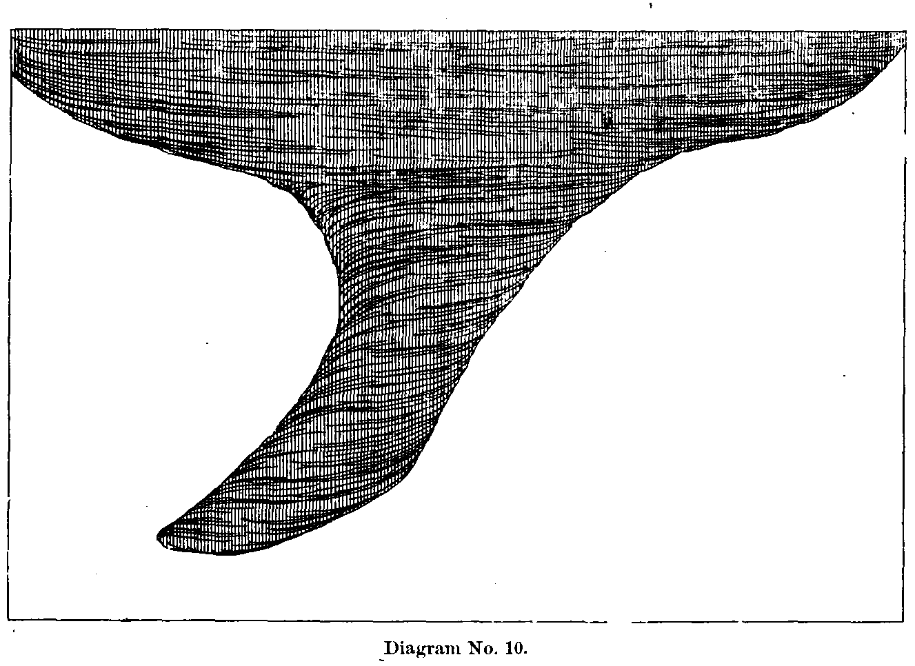 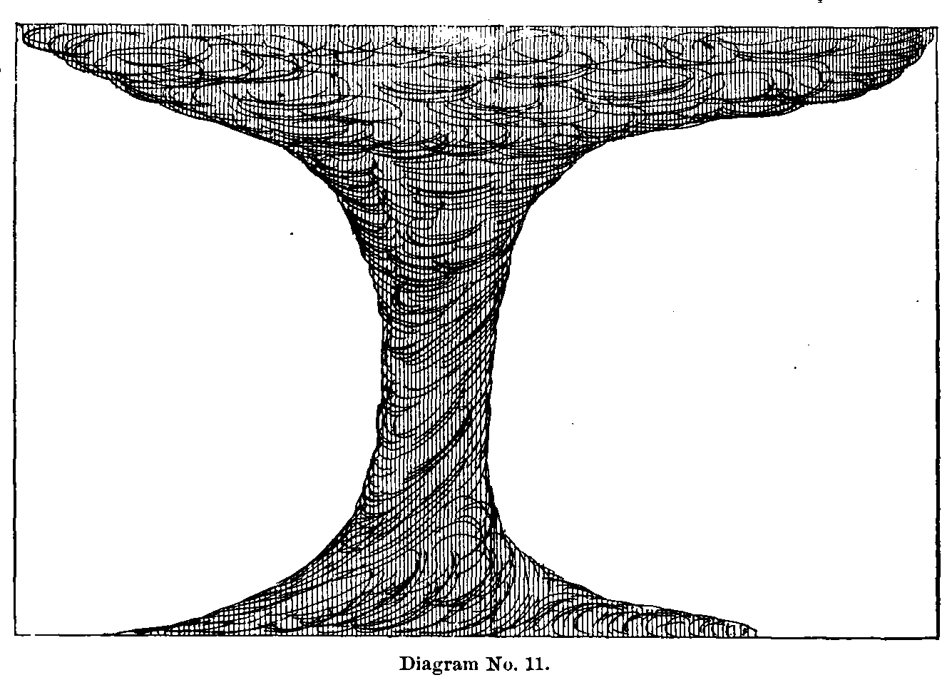
up Snipe Creek, the timber along the banks, especially on the W, side was twisted and broken in a fearful manner for a distance of about 6 miles (9.656 km). Large elm, oak, cottonwood, sycamore, and other trees, from 2 to 3 feet (0.9 m) in diameter, were wrenched from the earth as if they had been but bean poles. Thousands of cords of excellent timber were piled in promiscuous heaps, choking up the stream or obstructing roadways at the fords. At least one-third of the houses destroyed were new, having been erected in the spring, and not in all cases very substantially. The loss was exceedingly severe, and one hard to be borne by the "newcomers," under the peculiar circumstances, having just commenced to "break" the new pr irie [sic] and prepare a scanty subsistence for the coming winter, and also the fact that there were no available sources from which to obtain lumber to rebuild. The storm now entered upon the high prairie, crossing it between Beattie, 3 miles (4.828 km) to the W., and Axtell, 4½ miles (7.242 km) to the E., leaving the heads of the two branches of Snipe Creek. Mr. Martin, an old resident of Beattie, a small town of 150 inhabitants, situated upon high ground overlooking the W. fork of the Vermillion, stated that about 6 p. m. on May 30, saw distinctly, to the eastward about 2½ miles (4.023 km), a strange-looking cloud, shaped life a cone and resting upon its apex. During his residence of twenty-five years, had never seen anything like it before. The lower portion of the cloud seemed to be thrown forward at an angle of about 45°. (Diagram No. 10.) At times, when it descended to the ground, it would straighten up and the smaller end would spread out to nearly the dimensions of the upper portion. The roar was distinctly heard, sounding like the rumbling of several trains of cars passing through a ravine. (Diagram No. 11.) During the day the weather had been quite warm, especially in the afternoon, when it seemed very hard to breathe comfortably. About forty minutes before the tornado appeared, rain commenced followed soon after by hail as large as hens’ eggs. This precipitation was accompanied by a strong NW. wind, which came in gusts, the clouds moving towards the month of Snipe Creek, where other clouds could be seen moving from the SW. The SW. current seemed to be the stronger PAGE 58 -- TORNADOES OF MAY 29 AND 30, 1879.of the two, and to control and beat backward the clouds from the N. Finally they mixed together and shot off to the NE. with greater rapidity of motion. From that time, hardly five minutes intervened before the storm had passed Beattie, having traveled a distance of over 10 miles (16.093 km). Succeeding the storm, the wind changed to the W., and rain poured down in torrents, continuing with diminished energy, during the night and half the following day. During the evening and night it was very cold, necessitating overcoats for those who were rescuing the dead and wounded. In many instances the homeless sufferers were found huddled together over the ruins of their property, shivering with cold from the chilly, piercing current. Mr. M. A. Tucker, proprietor of the Sherman House, Beattie, stated that on the afternoon of the 30th threatening clouds began to collect in the SW. and NW., with a brisk southerly wind. Rain commenced between 4 and 5 p. m., and at 6 p. m., while the tornado was passing, it was so dark (although the sun was still over one hour high) that it became necessary to light a lamp. The wind now changed to the NW. accompanied with very heavy rain and large hail, veering to the N. and backing to the W. again, when the hail ceased, but the rain continued at intervals through the night and part of the following day. At 7 p. m. the sun came out very bright for a few moments, lighting up beautifully the western horizon. This was the first good rain during the past eight months. All the rain that fell during the winter and spring would not have wet the ground 6 inches (152 mm); in consequence the latter had become very dry and many were expecting a severe drought and loss of crops. Mr. J. Brawner, of Axtell, stated that it was about 6 p. m. when the tornado passed to the westward of the town, where it could be distinctly seen. About 5 p. m. light rain commenced with a northerly wind (during the day the wind had been from the S.), ceasing a few minutes before the tornado passed. The wind now backed to the E., continuing steady for a few moments, when it veered to the SSW., W., and NW. as the storm cloud passed to the NE. Hail and rain now fell in large quantities, with a very strong wind for nearly one hour, accompanied by an unusual decline in the temperature. South of Axtell, which, like Beattie, stands upon the highest ground in the surrounding neighborhood, the wind from the NW. did considerable damage in the timber and blew down several houses. At the small town of Guittard, 4 miles (6.437 km) N. of Beattie, no damage was done, although there occurred heavy rain with some hail and a strong NW. wind as the storm passed to the eastward. After crossing the Saint Jo and Denver City Railroad, between Beanie and Axtell, the cloud turned from NNE. to due NE., passing over a thinly inhabited region, for a distance of 11 miles (17.703 km). This portion of the country abounded in deep-wooded ravines and small streams, interspersed with rather narrow belts of rich, high, rolling prairie. During nearly the entire distance the cloud (preserving its characteristic shape), now descending, now rising and swaying from side to side as if suspended from an unseen hand, remained above the ground, committing no damage of any significance. This motion was visible for a distance of several miles on either side of its course. Five miles (8.047 km) NE. of Beattie and 6 miles (9.656 km) SW. of Saint Bridget, the cloud swooped down upon the small frame structure of Mr. Fuger, lifting it out of its inclosure (sic) of small cottonwood trees, carrying it over their tops (about 15 feet (4.6 m) high), where, in falling, it crushed to pieces, and the débris was strewn along the storm’s course for one fourth of a mile (0.402 km). This was the only damage to speak of, until Saint Bridget was reached. As the cloud passed over, or near to, some isolated settler, a loud rushing or roaring noise was heard, accompanied by a strong SW. wind, which at times was very severe, although the cloud did reach the ground. This violence of the SW. current was sufficiently attested by the large poles that were found placed against either side of the buildings to secure them upon their foundations, showing that in each case they had been badly shaken up. About 1 mile (1.609 km) S. of Saint Bridget, the cloud passed over the broad belt of heavy timber lining the rather precipitous banks of Manly Creek, which ran eastward quite irregularly to Turkey Creek, in the adjoining county of Nemaha. It now descended upon the highest point of ground at the Catholic mission, destroying an old school house 50 rods (251 m) SW. of the church. Brother Lambert, of the Order of Saint Benedict, and attached to this mission, stated that the storm passed about 6.30 p. m. It came up with a terrible roar and a basket-shaped cloud, whirling fearfully, and completely enveloping the place in darkness. (Diagram No. 12.) About twenty minutes before the tornado came, a light shower fell with a gentle northerly wind, which changed to the NE. as the storm cloud approached from the SW., blowing with considerable violence, but ceasing as the latter came PAGE 59 -- TORNADOES OF MAY 29 AND 30, 1879.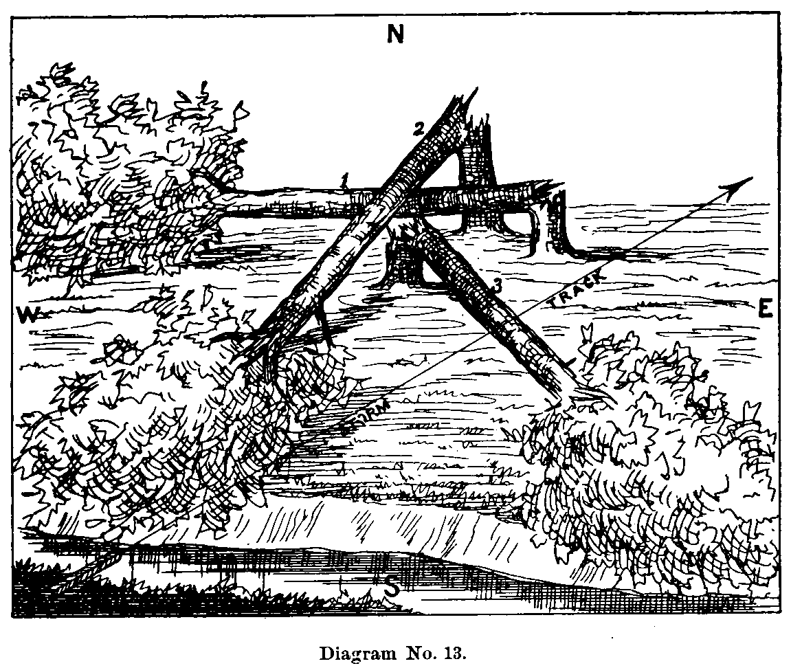 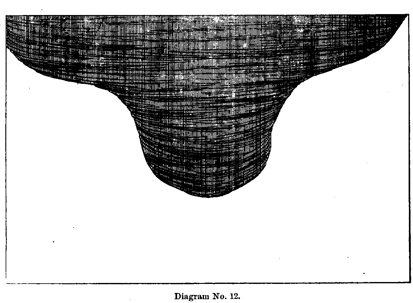
near, and by the time it had reached a point within one-fourth mile (0.402 km) of the church, almost a dead calm ensued. After the tornado cloud passed by, a most violent wind succeeded it from the W., accompanied with torrents of rain and large hail. The change was frightfully sudden, severely wrenching the new frame parsonage, a strong two story and a half building, which must have been thrown over had it not been bolted down to its stone foundations, but only the chimneys were blown off. The cloud after passing over the hill to the NE. struck Willow Creek, half a mile (0.805 km) to the N., a very small stream with broad bottoms, and running ESE., emptying into Manly Creek about 2½ miles (4.023 km) E. of Saint Bridget. (Diagram No. 13.) On this creek, directly N. of the mission, the storm unroofed the house of Dennis Morian, carrying the débris to the E. Passing down Willow Creek to near its mouth, uprooting and twisting off the scanty timber in places, it left it, at the Nemaha County line, passing gradually up to the high prairie, over which it remained above the ground for about 1 mile (1.609 km), when it again struck Manly Creek where it bends to the NE. Here, on a slight rise of ground, but rather below the general level, it destroyed the log house of Mr. Corcoran. It now reached the bottom of the valley and crossed a portion of it which cut into the high prairie to the NW. Ascending the high ground which bounded this small inlet to the E., the storm destroyed the small stone house of Mr. Hickman, situated about half way up the southern slope of the hill. The débris in this instance and the former was carried along the storm’s path to the NE. for from 50 to 80 rods (251 to 402 m). Passing over this high point of land which pushed out into the valley, the cloud again encountered the creek, keeping near its western bank and destroyed the timber in a fearful manner for a distance of about 2 miles (3.219 km), when it bore slowly to the N., leaving the creek which ran nearly due E. Its course now became ENE., as it ascended the high prairie where it demolished a school house in district 26, Clear Creek Township, Nemaha County. The building stood on the N. side of the storm’s center and fronted the S. It was first struck on the S. end, bursting in the door and carrying the building off the foundation 60 feet (18.3 m) to the N., where it went to pieces and the débris scattered to the NE. and E. One-quarter of a mile (0.402 km) to the E. the large stone house of Mr. McCaffrey was unroofed, and several of his outbuildings demolished. Part of the roof was deposited a few rods E. of the house, PAGE 60 -- TORNADOES OF MAY 29 AND 30, 1879.but the largest portion had not been seen since the storm, though vigilant search in every direction had been made for it. Large cottonwood trees from 12 to 18 inches (305 to 457 mm) in diameter, standing a few yards E. and SE. of the house, were broken off from 8 to 15 feet (2.4 to 4.6 m) above the ground. The width of the storm track at this point was about 300 yards (274 m). The storm passed at about 6.45 [sic] p. m., after which the sun came out quite pleasantly, but the air was very chilly, with a strong westerly wind prevailing. It rained very heavily after 7 p. m., with a NW. wind, and at intervals through the night. The following day was fair, but very cool. Mr. McCaffrey’s house stood one-quarter of a mile (0.402 km) W. of Turkey Creek and three-quarters of a mile (1.207 km) N. of Manly Creek, upon a considerable rise of ground sloping to the SE. The latter creek empties into the former at this point, and both pass into clear [sic] creek [sic] l ½ miles (2.414 km) to the SE., which empties into the Nemaha River 5½ miles (8.851 km) to the E. In crossing Turkey Creek to the NE. five small buildings, situated along the creek bottom, were unroofed and partially demolished. The heavy timber for a width of half a mile (0.805 km) N. and S. was torn and twisted in the usual manner. Directly E. of McCaffrey’s the eastern banks of the creek were very precipitous, but about 80 rods (402 m) farther to the N. a little ravine 150 yards (137 m) wide cut up through the bluffs to the high prairie beyond. Up this "draw" the storm cloud passed with the utmost display of violence, tearing up and breaking off nearly every tree and bush throughout its extent. Half a mile (0.805 km) from the top of the bluffs and on still higher ground the storm unroofed the small house of Mr. Gopelt, a German farmer. The cloud now rose entirely from the ground, and passed over the high "divide" between Turkey Creek and the Nemaha River for a distance of 6 miles (9.656 km), crossing the latter where it passed the Nebraska line, 11 miles (17.703 km) S. of Cincinnati, a small town in the extreme SE. corner of Pawnee County, Nebraska. During this part of its course no damage was committed so far as careful examination could reveal. Over the many little wooded ravines which it passed there was not the slightest evidence of its destructive energy, but a strong SW. wind followed in its wake, succeeded by heavy rain and in some cases hail, with a cold westerly wind Dr. A. H. Jackson, of Cincinnati, stated that the storm passed between 1 and 2 miles (1.609 to 3.219 km) S. of the town at 7 p. m., or perhaps a few minutes later. During the day the wind bad been mostly from the SE., but very changeable, as well as the clouds, which sometimes covered the zenith and portions of the horizon, and then entirely disappeared. It was very warm, especially in the afternoon. About 4 p. m., the clouds began to gather thickly and threatening in the W. and looked very peculiar, sometimes red, changing alternately to muddy, grayish blue and black. After this series of changes had been going on for some time, small scud clouds were seen to break off from the larger masses and move rapidly about each other, finally concentrating in the SW., the wind at the surface being still from the SE. In the course of a few minutes the wind entirely ceased, followed by a short period of calm, when, upon looking again to the SW., distant about 3 miles (4.828 km), a peculiar barrel-shaped cloud of a dirty smoky color was seen rather high up in the air. The wind now sprang up very strong from the SW., and the cloud passed by to the S., disappearing from view in the heavy timber along the Nemaha River, which it tore up badly on the property of Mr. J. P. Cone for a width of 240 yards (219 m). While the tornado was passing the wind changed suddenly to the NW. and blew very violently for from ten to fifteen minutes, whipping off the tops of some of the trees in the town and overturning several rods of fence. The wind was accompanied with heavy rain and some hail, but it ceased with the decline of the heavy wind, and no more fell during the evening or night. The clouds seemed to break away and clear up in the W., but a very cool westerly wind continued, even through the following day--a very unusual occurrence for this time of the year. The storm cloud again lifted from the earth while upon the high prairie E. of the Nemaha River, and passed over the southwestern portion of Richardson County, Nebraska, to the small town of Dawson’s Mills, on the Nebraska and Atchison Railroad. During this portion of its course, about 20 miles (32.187 km) in length, it left scarcely any evidence of its destructive power, except while again crossing the southern branch of the Nemaha, where it bends to the NW., and about half way between the towns of Athens and Salem. The timber was twisted and broken in considerable quantities, sufficient, at least, to unquestionably decide the work as the result of the tornado’s characteristic whirl. The track was comparatively narrow, and the destruction mostly confined to the tree tops, especially on the western bank, where its work first commenced. The cloud might have reached PAGE 61 -- TORNADOES OF MAY 29 AND 30, 1879. the
earth in several places previous to its crossing the river, but no evidence from
any source could be obtained of such a fact, principally because no portion of
the storm’s entire path was so completely devoid of creeks, timber, and
habitations. The entire distance from Cincinnati northeastward to the NW. bend
of the Nemaha, about 12 miles (19.312 km), was a bare prairie, offering nothing but a
monotonous surface of grass, yet not by any means level, as it was perhaps the
most abruptly undulating of any portion of the whole track. The remaining
portion of its course lay over the high divide between the south branch of the
Nemaha and the main river, which runs from NW. to SE., through the southeastern
portion of Richardson County, and empties into the Missouri. On the eastern bank
of the Nemaha, and at the foot of high bluffs surrounding it on the W., N., and
E., stood the town of Dawson’s Mills, the last village encountered in the
track of the storm. Michael Riley, the principal merchant of the place, stated
that the storm reached them about 7.10 [sic] p. m. There had been no rain during
the day until about ten minutes before the storm cloud came upon them. The rain
was accompanied with hail of very large size, but scattering. The tornado came
up from the SW., over the bluffs along the river, looking like a waterspout, and
attended with great commotion in its interior, and a loud, roaring noise. As it
passed, a strong current from the SW. crushed in the front of the store and tore
down all the shelving on the N. side. Mr. Mead, another merchant at Dawson’s
Mills, stated that during the day the wind had been from the SE., and the
weather was very pleasant until just at evening, when it clouded up a little
with a SW. wind. About thirty minutes before the storm, dark, threatening clouds
began to appear in the SW. and N., gradually approaching each other until
covering the western horizon. The two seemed to join in the NW., when there
resulted a great commotion in the clouds, some moving one way and some another.
The entire operation was not distinctly visible, as the observer was too low
down behind the western hills to watch all of the changes. A great roaring was
now heard, like the rambling of several trains of cars, while the wind was still
from the SW. As the roaring became louder, indicating the approach of the storm,
a peculiar cloud, shaped like a waterspout, made its appearance. The wind now
commenced to lull, and soon a calm ensued, as on the eve of some awful
catastrophe, which filled the inhabitants with terror. It had now become so dark
that few things could be distinguished. The cloud did not dip down into the
valley, as was expected, but moved over the bluffs to the N. of the town,
distant about 1 mile (1.609 km). From all appearances it had hardly passed ere [sic] a
violent wind sprang up from the NW., accompanied with a few large hailstones and
rather heavy rain, which dashed down the bluffs and through the valley,
committing considerable destruction. The NW. current slacked up a little in a
few seconds, when it was succeeded by an equally violent wind from the N., the
rain continuing. The wind gradually veered [sic] to the W., with a much lower
temperature, producing a chilling effect upon the atmosphere for the next
forty-eight hours. The rain continued until about 10 p. m., when all was quiet,
commencing again with a westerly wind shortly before morning. The Catholic
church, 26 by 50 feet (7.9 to 15.2 m), with ,16-foot
(4.9 m) studding, was lifted bodily from the
foundation and carried to the SE., the SE. corner 10 feet (3.0
m), and the NE. corner 14 feet (4.3 m). After striking the ground, the building moved 6 feet
(1.8 m) to the S., plowing
up. the surface to a depth of several feet, when it fell to pieces. There were
at the time about fifty persons in the church, in attendance at evening meeting;
none were killed, but several seriously injured; most of the people sought
protection under the seats, upon which the débris fell, thus saving many
from a painful death. One piece of flooring 12 feet (3.7
m) long and 6 inches (152 mm) wide was
carried 120 yards (110 m) to the SE., and considerably lighter débris was
carried 150 yards (137 m) in the same direction, and deposited in the garden of Mr.
Webb. The wagon-shop of Mr. S. C. Barlow, 18 by 40 feet (5.5
to 12.2 m), and two stories high,
with an addition to the S. 12 by 20 feet (3.7 to 6.1 m), had its E. end moved 18 inches
(457 mm) to the
S., but the W. end remained firm. His stable, a few rods W. of the shop, 12 by
17 feet (3.7 to 5.2 m), and 9 feet (2.7
m) high, was picked up and blown entirely through two board
fences, about 60 feet (18.3 m) apart and five boards highs tearing them down for a width
of 25 feet (7.6 m). The barn contained 1½ tons of hay, which was pretty thoroughly
scattered about the town. the
earth in several places previous to its crossing the river, but no evidence from
any source could be obtained of such a fact, principally because no portion of
the storm’s entire path was so completely devoid of creeks, timber, and
habitations. The entire distance from Cincinnati northeastward to the NW. bend
of the Nemaha, about 12 miles (19.312 km), was a bare prairie, offering nothing but a
monotonous surface of grass, yet not by any means level, as it was perhaps the
most abruptly undulating of any portion of the whole track. The remaining
portion of its course lay over the high divide between the south branch of the
Nemaha and the main river, which runs from NW. to SE., through the southeastern
portion of Richardson County, and empties into the Missouri. On the eastern bank
of the Nemaha, and at the foot of high bluffs surrounding it on the W., N., and
E., stood the town of Dawson’s Mills, the last village encountered in the
track of the storm. Michael Riley, the principal merchant of the place, stated
that the storm reached them about 7.10 [sic] p. m. There had been no rain during
the day until about ten minutes before the storm cloud came upon them. The rain
was accompanied with hail of very large size, but scattering. The tornado came
up from the SW., over the bluffs along the river, looking like a waterspout, and
attended with great commotion in its interior, and a loud, roaring noise. As it
passed, a strong current from the SW. crushed in the front of the store and tore
down all the shelving on the N. side. Mr. Mead, another merchant at Dawson’s
Mills, stated that during the day the wind had been from the SE., and the
weather was very pleasant until just at evening, when it clouded up a little
with a SW. wind. About thirty minutes before the storm, dark, threatening clouds
began to appear in the SW. and N., gradually approaching each other until
covering the western horizon. The two seemed to join in the NW., when there
resulted a great commotion in the clouds, some moving one way and some another.
The entire operation was not distinctly visible, as the observer was too low
down behind the western hills to watch all of the changes. A great roaring was
now heard, like the rambling of several trains of cars, while the wind was still
from the SW. As the roaring became louder, indicating the approach of the storm,
a peculiar cloud, shaped like a waterspout, made its appearance. The wind now
commenced to lull, and soon a calm ensued, as on the eve of some awful
catastrophe, which filled the inhabitants with terror. It had now become so dark
that few things could be distinguished. The cloud did not dip down into the
valley, as was expected, but moved over the bluffs to the N. of the town,
distant about 1 mile (1.609 km). From all appearances it had hardly passed ere [sic] a
violent wind sprang up from the NW., accompanied with a few large hailstones and
rather heavy rain, which dashed down the bluffs and through the valley,
committing considerable destruction. The NW. current slacked up a little in a
few seconds, when it was succeeded by an equally violent wind from the N., the
rain continuing. The wind gradually veered [sic] to the W., with a much lower
temperature, producing a chilling effect upon the atmosphere for the next
forty-eight hours. The rain continued until about 10 p. m., when all was quiet,
commencing again with a westerly wind shortly before morning. The Catholic
church, 26 by 50 feet (7.9 to 15.2 m), with ,16-foot
(4.9 m) studding, was lifted bodily from the
foundation and carried to the SE., the SE. corner 10 feet (3.0
m), and the NE. corner 14 feet (4.3 m). After striking the ground, the building moved 6 feet
(1.8 m) to the S., plowing
up. the surface to a depth of several feet, when it fell to pieces. There were
at the time about fifty persons in the church, in attendance at evening meeting;
none were killed, but several seriously injured; most of the people sought
protection under the seats, upon which the débris fell, thus saving many
from a painful death. One piece of flooring 12 feet (3.7
m) long and 6 inches (152 mm) wide was
carried 120 yards (110 m) to the SE., and considerably lighter débris was
carried 150 yards (137 m) in the same direction, and deposited in the garden of Mr.
Webb. The wagon-shop of Mr. S. C. Barlow, 18 by 40 feet (5.5
to 12.2 m), and two stories high,
with an addition to the S. 12 by 20 feet (3.7 to 6.1 m), had its E. end moved 18 inches
(457 mm) to the
S., but the W. end remained firm. His stable, a few rods W. of the shop, 12 by
17 feet (3.7 to 5.2 m), and 9 feet (2.7
m) high, was picked up and blown entirely through two board
fences, about 60 feet (18.3 m) apart and five boards highs tearing them down for a width
of 25 feet (7.6 m). The barn contained 1½ tons of hay, which was pretty thoroughly
scattered about the town.
PAGE 62 -- TORNADOES OF MAY 29 AND 30, 1879.Upon the prairie above the town, which formed the high divide between the Muddy and the Nemaha rivers, the house of Mr. Riley and the barn of Mr. Dawson were entirely destroyed. Here the tornado performed its characteristic work. (Diagram No. 14.) The house stood about 200 feet (61.0 m) W. of the storm’s center, and was very solidly constructed of oak sills and studding. The wind struck it first from the NW., moving it from its foundation and then tearing it to pieces, scattering the débris to the S., SE., and E., some parts being found half a mile (0.805 km) distant. Only about one third of the flooring could be found at all. Two of the house sills, 10 by 12 inches (254 to 305 mm) and 16 feet (4.9 m) long, were carried, one to the S. 200 yards (183 m) and the other 300 yards (274 m) to the SE. One-fourth of a mile (0.402 km) in a direct line to the NNE. stood the barn of Mr. Dawson, a large and firmly-built structure 30 feet (9.1 m) square with 16-foot posts. It was torn to pieces on the foundation, the wind striking it broadside from the W., crashing in the heavy oaken frame as if it had been a toy shop, and scattering the débris to the S. and SE. Two of the sills, 14 inches (356 mm) square and 30 feet (9.1 m) long, were found 23 yards (21 m) to the SE. A pile of loose lumber, 50 feet (15.2 m) WSW. of the barn, was not harmed; also the house, 300 feet (91.4 m) in the same direction, escaped. Grass, hay, weeds, pieces of furniture, clothing, and boards were scattered along the storm’s path for a mile (1.609 km) or more. This constituted the last destructive act of the true tornado, so far as any reliable information could be obtained. Nothing was seen or heard of further on, in the way of a peculiarly-shaped cloud or of any destruction where a whirling current. or cloud became a factor. Of course, by the time the tornado reached Dawson’s Mills it was very nearly sundown, and any observation upon the movement or appearance of the cloud would be attended with much difficulty, especially as it was now moving above the ground, and therefore much diminished in size. Rev. J. W. Taylor, an itinerant Methodist minister at Saint Deroin, 18 miles (28.968 km) due NE. of Dawson’s Mills, and on the Nebraska side of the Missouri River, stated that in his travels to and fro between these points he had found only one instance of destructive action (a farmer’s house), which occurred in the vicinity of Baraday, a squall village 6 miles (9.656 km) SW. of Saint Deroin. The building, situated in a small "draw" up which the storm evidently passed, was completely destroyed, together with all of the outbuildings. The house was very well built, being mach stronger than the buildings of most of his neighbors, which were perfectly unharmed, though not a quarter of a mile (0.402 km) distant on the high prairie. The family, consisting of four, were in the house at the time, but none were seriously injured save the father. The broken furniture, parts of bedding, clothing, boards, and shingles were strewn along the track to the SE. and E. for a distance of from one-half to three-fourths of a mile (1.207 km). The time of this destruction was given as 7.30 [sic] p. m., which would agree very well with the time at Dawson’s Mills of 7.10 [sic] p. m., making the progressive velocity of the storm between these two points (supposing this destruction to have been caused by the tornado) at about 36 miles (58 kph) per hour, rather above the average velocity fur the whole storm track, but not at all excessive for small portions. As no one mentioned to Mr. Taylor in connection with this destruction anything about a tornado, and as no questions were put by him respecting the possibility or nature of such a storm, we are left somewhat in doubt concerning the course and conditions of the tornado after leaving Dawson’s Mills. At Saint Deroin, as stated by Mr. Taylor, there was no severe storm of wind during the day, but an exceedingly heavy fall of rain, mixed with some hail, which came from the NW. between 7 and 8 p. m. No damage was committed. Thought that the heaviest part of the storm went W. of him. It was clearly determined by the unanimous testimony of many people, and a considerable amount of destruction, that a very heavy NW. storm of wind and rain, bat not much hail, prevailed between the hours of 7 and 9 p. m. over the eastern portion of Richardson County, Nebraska, the southwestern part of Iowa, and the northwestern part of Missouri. Now, it is more than likely, from the coincidence of time and place, that the tornado finally lost its identity in this heavy storm, which had come many miles from the NW., in Iowa and Nebraska, crossing the path of the tornado E. of Dawson’s Mills. But notwithstanding what may be thought or said, it is an indisputable fact that the identity of the tornado was extinguished where the NW. storm began its work. I obtained no reports of any NW, storm W. of Dawson’s Mills, but its track seemed to be confined to the sections E. of the Nemaha River. On the farm of Mr. John J. Hart, 2½ miles (4.023 km) SE. of Dawson’s Mills, and between 7 and 8 p. m., a large stable, 36 by 40 feet (11.0 to 12.2 m), and containing eight horses, was blown to pieces by a heavy NW. wind. The house of Mr. James Harrison, 1¾ miles (2.816 km) SSE. of Dawson’s Mills, was completely demo- PAGE 63 -- TORNADOES OF MAY 29 AND 30, 1879.lished about the same time, a heavy NW. wind prevailing, accompanied with rain and hail. Three and a half miles (0.805 km) to the SE., the house of Mr. John Fisher had the doors and windows blown in, from the NW.; the wind was attended with rain and hail and lasted for about twenty minutes. Mr. D. W. Easley, of Humboldt, a small town 8 miles (12.875 km) NW. of Dawson’s Mills, reported a very heavy NW. wind with torrents of rain, but not much hail, as occurring between the hours of 7 and 8 p. m. and lasting about thirty minutes. It was accompanied with an unusual display of thunder and lightning. Several small outbuildings and chimneys were blown down, and a new drug store badly racked [sic] Had had no rain before for several weeks, during which time the wind had been southerly and most of the time very brisk. Mr. M. O’Brien, of Falls City, about 14 miles (22.531 km) SE. of Dawson’s Mills, reported a strong NW. wind with very heavy rain and small hail about 7.30 [sic] p. m. Two small houses were moved from their foundations and several outbuildings were blown over. The house of Henry Shaw, 7 miles (11.265 km) N. of the town, was completely wrecked by the same storm. This storm also visited the town of Craig, just across the Missouri River, in the northwestern part of Nodaway County, Missouri, at about 7.30 [sic] p. m., and still later the southern portions of Nodaway, Holt, and Andrew Counties. Mr. Fred. Meyers, of Craig, reported that a heavy NW. storm visited that place at the time above given. Very heavy, dark clouds began to gather in the N. and NW. rather early in the afternoon, and between 6 and 7 p. m. other threatening clouds appeared in the SW., apparently moving up the Missouri River. As they swung around to the NW. the two sets of clouds apparently joined, resulting in an unusual commotion and wrestling of the opposing forces, when the wind suddenly veered from the S., where it had been during most of the day, successively to the W., NW., and N., blowing with great violence from all the points. It was accompanied with exceedingly heavy rain, thunder and lightning, and some hail. From forty to fifty chimneys were demolished, the front of a large drug store blown out, and the building itself (24 by 100 feet (7.3 to 30.5 m)) was careened over to the S. and E. A photograph car was turned over several times, and a large and costly wind-mill, belonging to the railroad company, completely destroyed. A "Woods harvester" weighing about 1,200 pounds was moved along the ground for 80 yards (73 m) to the SE. The storm, after leaving the town, passed out on the high prairie to the SE., destroying a great amount of fencing and timber and several small buildings. At Mound City, 8 miles (12.875 km) SE. of Craig, the Methodist church was moved from its foundation, and several small buildings blown down. Three miles (4.828 km) farther to the SE. the outbuildings on the farm of Mr. McIntyre, in Benton Township, were entirely destroyed. Concluding the tornado’s track at Dawson’s Mills, or a few miles eastward, we find that its entire course from the northwestern portion of Riley County, Kansas, measured between 98 and 100 miles (157.716 to 160.934 km), which it traversed in two hours and fifty-five minutes, or at the rate of 30.5 miles per hour (49 kph). In some portions of its track the rate was perhaps somewhat greater, several persons estimating 40 to 50 miles per hour (64 to 80 kph) as quite within the range of its progressive velocity. The tornado’s general course was due NE., but subject to several variations, as I have carefully noted in this description, and as will be seen by reference to the accompanying topographical map of its track.
|
Contact InformationElectronic mail address Last revised: May 21, 2006 |
 NW.
A huge and heavy mass of dark clouds lined the northern part of the western
horizon, rapidly increasing in size and portentous appearance. In a few moments
a lighter mass of clouds shot up from the SSW., while a similar action obtained
in the N. These two clouds met at a point some distance SW. of Waterville, and
at what appeared to have been about 1½ miles (2.414 km) above the ground. They ran forward
and wound round each other in a most fantastic but awful manner, as if in a
death struggle to see who should gain the mastery. In a few seconds a large
fragment was thrown off from the main mass in the shape of a cornucopia. This
smaller cloud spun round and round with great rapidity like a top, and ran to
the earth at an angle of about 45°, taking a NE. direction between Waterville
and Blue Rapids. It was about one half mile (0.805 km)
wide at the top and tapered down to
a few yards at the bottom. Its speed could be discerned much better than the
main cloud moving to the SE. This "fragment" spoken of here is the
"Waterville tornado," which is fully described elsewhere. The main
cloud took the shape of a huge basket over 1-1/2 miles (2.414
km) wide and rounding off at
the bottom. (Diagram No. 7.) All at once it made a sudden descent towards the
earth, the lower part lengthening out and growing narrower, reaching the surface
at an angle of about 45°. It now ceased the forward movement, and, standing
upright on its narrow base, spun around like a top, throwing up angry jets of
vapor through the vortex. As the cloud raised from the ground it swung over a
little to the NW., and then gradually back on its course again, moving rapidly
to the E., bounding over the hills, swinging first to the right and then to the
left, then standing upright upon its base and again whirling violently for an
instant. It now seemed to enlarge and fill up on the sides, pressing down to the
earth until nothing but a broad, heavy, storm cloud appeared. In a few seconds
another small neck ran down, resembling a funnel, but the huge mass of cloud was
so near the earth that the column appeared to almost lie upon the ground, as it
ran forward over the surface with lightning rapidity. The large cloud during
this time was spitting out angry forks of dark smoke, which would dart and flash
in every direction. They now disappeared again, leaving but the broad heavy
cloud as before described. The storm had now reached Mr. Preston’s farm near
the city, enveloping it in a dense, milky mist, but the cloud was very dark near
the top. Mr. Preston now came down from his place of observation to provide for
the safety of his family. He further stated that for five or six days previous
to the storm a warm S. wind had prevailed. On the afternoon of May 29 a stiff
upper current was noticed by the action of the clouds to be passing southward,
producing considerable commotion in the latter, throwing them backwards and
upwards as if caused by contact with the warm southerly current moving at the
surface. On Friday morning the opposing currents were still running rapidly, but
accompanied with greater commotion in
NW.
A huge and heavy mass of dark clouds lined the northern part of the western
horizon, rapidly increasing in size and portentous appearance. In a few moments
a lighter mass of clouds shot up from the SSW., while a similar action obtained
in the N. These two clouds met at a point some distance SW. of Waterville, and
at what appeared to have been about 1½ miles (2.414 km) above the ground. They ran forward
and wound round each other in a most fantastic but awful manner, as if in a
death struggle to see who should gain the mastery. In a few seconds a large
fragment was thrown off from the main mass in the shape of a cornucopia. This
smaller cloud spun round and round with great rapidity like a top, and ran to
the earth at an angle of about 45°, taking a NE. direction between Waterville
and Blue Rapids. It was about one half mile (0.805 km)
wide at the top and tapered down to
a few yards at the bottom. Its speed could be discerned much better than the
main cloud moving to the SE. This "fragment" spoken of here is the
"Waterville tornado," which is fully described elsewhere. The main
cloud took the shape of a huge basket over 1-1/2 miles (2.414
km) wide and rounding off at
the bottom. (Diagram No. 7.) All at once it made a sudden descent towards the
earth, the lower part lengthening out and growing narrower, reaching the surface
at an angle of about 45°. It now ceased the forward movement, and, standing
upright on its narrow base, spun around like a top, throwing up angry jets of
vapor through the vortex. As the cloud raised from the ground it swung over a
little to the NW., and then gradually back on its course again, moving rapidly
to the E., bounding over the hills, swinging first to the right and then to the
left, then standing upright upon its base and again whirling violently for an
instant. It now seemed to enlarge and fill up on the sides, pressing down to the
earth until nothing but a broad, heavy, storm cloud appeared. In a few seconds
another small neck ran down, resembling a funnel, but the huge mass of cloud was
so near the earth that the column appeared to almost lie upon the ground, as it
ran forward over the surface with lightning rapidity. The large cloud during
this time was spitting out angry forks of dark smoke, which would dart and flash
in every direction. They now disappeared again, leaving but the broad heavy
cloud as before described. The storm had now reached Mr. Preston’s farm near
the city, enveloping it in a dense, milky mist, but the cloud was very dark near
the top. Mr. Preston now came down from his place of observation to provide for
the safety of his family. He further stated that for five or six days previous
to the storm a warm S. wind had prevailed. On the afternoon of May 29 a stiff
upper current was noticed by the action of the clouds to be passing southward,
producing considerable commotion in the latter, throwing them backwards and
upwards as if caused by contact with the warm southerly current moving at the
surface. On Friday morning the opposing currents were still running rapidly, but
accompanied with greater commotion in