Kansas Paddler's Guide - Volume 1
Last Edited: 04/04/2007
Select Rivers & Streams in
Central Kansas:
NOTES:
- See the KANSAS PADDLER Home Page (http://www.kansas.net/~tjhittle) for (Kansas USGS)
river flow information and Kansas Canoe Association trip information.
- For revisions/updates/or additions to the list below, Email: tjhittle@kansas.net
- Remember that all Kansas streams but the Kansas River, Arkansas River, and Missouri
River flow over "private property", as interpreted by the Kansas Supreme Court.
Seek permission to float all private streams. Use your best judgment
and
extreme caution to avoid the legal consequences of trespass.
- Class Difficulty Ratings are subjective. Use your own
judgment. There are elements of danger in each of the streams listed.
- Flow levels are easiest checked by logging onto the Kansas USGS Real Time Gauge link
under the KANSAS PADDLER Home Page
Water Conditions for River Runners page.
- Before planning your trip, return to the Kansas Paddler, to download the most current
edition
- Revised: 04/04/07
RIVER INFORMATION FORMAT
(The Kansas Atlas & Gazetteer by DeLorme is an indispensable
map guide for the information provided below)
 Stream Name:
 - River Map (generally a large printable .jpg map)
Smoky
Hill River w/4 sections listed:
 Solomon, KS to Abilene, KS. Use old Hwy 40
(4th st) for
your shuttle road, ~9.0 miles.
Solomon, KS to Abilene, KS. Use old Hwy 40
(4th st) for
your shuttle road, ~9.0 miles.- 16.0 river miles
- Put-in: Solomon, KS, South of town on the Solomon Rd (listed incorrectly
in the Gazetteer as Barn Rd), Use the bridge, just upstream and on river
right. Wind through downtown Solomon to E. Main. Turn South on Pine
St. Head South on Solomon Rd (Pine St). Across from the access, you
will see the confluence of the Solomon and Smoky Hill Rivers.
- Alt Access: Holland Rd. bridge, about 5 miles East of Solomon, KS on old
Hwy 40. Best access is on RL, just down stream from the bridge.
- Take-out: Abilene, KS - Hwy 15 bridge, South side
or river under the bridge.
- Caution: Class II+ rapids (may need to scout); some downed
trees & strainers; access fair. River corridor is fairly protected from winds.
- good year around flow, fun scenic float w/easy shuttle
- 350 cfs / Flow levels are easiest checked by logging onto the Kansas
USGS Real Time Gauge link under the KANSAS PADDLER Home Page Water Conditions for River
Runners page.
- Class II+ - does contain some minor rapids and a number of strainers, so caution
should be used.
- Hwy 15
(South of Abilene) to Enterprise, KS. Use old Hwy 40 or CR 2200 for
your shuttle road
- 11.0 river miles
- Put-in: Abilene, KS - Hwy 15 bridge (RR), South side or
river under the bridge.
- Take-out: Enterprise, KS bridge (RR) over the Smoky Hill river, Hwy 43, South side and
upstream. Use the concrete drainage swale.
-
Caution: Class II+ rapids (may need to scout); some downed
trees & strainers; access fair. River corridor is fairly protected from winds.
- good year around flow, fun scenic float w/easy shuttle
- 350 cfs / Flow levels are easiest checked by logging onto the Kansas
USGS Real Time Gauge link under the KANSAS PADDLER Home Page Water Conditions for River
Runners page.
- Class II+ - does contain some minor rapids and a number of strainers, so caution
should be used.
- Enterprise, KS to Chapman, KS. Use old Hwy
40 for your shuttle road.
- 20.0 river miles
- Put-in: Enterprise, KS bridge over the Smoky Hill river, off Hwy
43, South side and upstream. Use the concrete drainage swale.
- Take-out: Chapman, KS bridge over the Smoky Hill River. South side.
Has some room for parking. Access is steep, muddy and poor. River corridor is fairly
protected from winds.
- Caution: Class II+ rapids (need to scout); some downed
trees & strainers
- good year around flow, fun scenic float w/easy shuttle.
Long winding trip. Should have good flow before attempting.
- 350 cfs / Flow levels are easiest checked by logging onto the Kansas
USGS Real Time Gauge link under the KANSAS PADDLER Home Page Water Conditions for River
Runners page.
- Class II+ - does contain some minor rapids and a number of strainers, so caution
should be used.
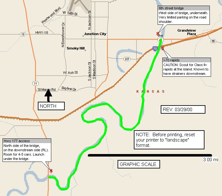
- (Section around Junction City, KS) - Hwy 77 to 6th St. bridge in Junction City, KS
- - River map - Hwy 177 -
Junction City, KS only
- 9.0 river miles
- Put-in: Hwy 77 bridge (RL) to access South of Junction City, KS under the Hwy 77 bridge
- Take-out: 6th Street bridge - Junction
City (RL), under the bridge. Access is
steep, muddy, and poor
- Caution: Class II+ rapids (need to scout); some downed
trees & strainers; wind advisory. River corridor is fairly open and susceptible to
winds.
- good year around flow, fun scenic float w/easy shuttle
- 345 cfs / Flow levels are easiest checked by logging onto the Kansas
USGS Real Time Gauge link under the KANSAS PADDLER Home Page Water Conditions for River
Runners page.
- Class II+ - does contain some minor rapids, so caution should be used
Republican
River - w/ 4 sections listed:
Milford
Reservoir to
Junction City, KS
7.0 river miles
Put-in: Just below the tubes at Milford
Reservoir at the South Outlet Park fishermen's accres (RR), about 300 yds
below the outlet
Take-out: K-18 - (Grant Ave. Park) bridge on (RR)
Caution: watch for downed trees and strainers / Access is generally fair
Must have good flow from Milford Reservoir, check USGS or USACOE outflow levels
400 cfs / Flow levels are easiest checked by logging onto the Kansas
USGS Real Time Gauge link under the KANSAS PADDLER Home Page Water Conditions for River
Runners page.
Class I
Clay Center, KS to
Broughton Bridge
8.0 river miles
Put-in: Hwy 15 bridge - South side, under the bridge on (RR)
Take-out: Broughton Bridge (RL) - The
current status of the Broughton Bridge, It is now rebuilt and has been open
to vehicles since January 2004. KDWP has said that they and several area
non-profit hunting groups and the Junction City Chamber of Commerce have
shown interest in building a boat ramp and parking area near the bridge.
Caution: watch for downed trees and strainers / Access is generally fair
Scenic
400 cfs / Flow levels are easiest checked by logging onto the Kansas
USGS Real Time Gauge link under the KANSAS PADDLER Home Page Water Conditions for River
Runners page.
Class I+
Broughton bridge
to Milford Reservoir
9.0 river miles
Put-in: Broughton Bridge - closed to vehicles, but still accessible (RL)
Take-out: Milford Reservoir - KDWP boat access
Caution: watch for downed trees and strainers / Access is generally fair
Scenic with some lake water
400 cfs / Flow levels are easiest checked by logging onto the Kansas
USGS Real Time Gauge link under the KANSAS PADDLER Home Page Water Conditions for River
Runners page.
Class I
Concordia, KS
to access off county road below County Road bridge
7.0 river miles
Put-in: Hwy 81 bridge (RL), north of Concordia - difficult access in rainy weather
Take-out: River Road access (RR) - North off Hwy 9,
4 1/2 miles East of Concordia
Caution: watch for downed trees and strainers / Access is generally fair
Very scenic
400 cfs / Flow levels are easiest checked by logging onto the Kansas
USGS Real Time Gauge link under the KANSAS PADDLER Home Page Water Conditions for River
Runners page.
Class I+
(Many other upstream sections area
runnable with poor access and difficult landowner permission issues)
Little
Blue River, Near Waterville, KS:
NOTE: Use a Kansas Gazetteer to help with directions and roads
Bridge north of Barnes, KS on CR 148 to County
Bridge north of Waterville, KS
7.0 river miles
Put-in: Bridge - RR - North Barnes, KS on
CR 148
Take-out: Bridge - RL - North west of Waterville, KS on county
gravel road
Caution: Watch for downed trees & strainers / Access is poor
Very scenic; good gravel bar camping
400 cfs / Flow levels are easiest checked by logging onto the Kansas
USGS Real Time Gauge link under the KANSAS PADDLER Home Page Water Conditions for River
Runners page.
Class II
- River map -
Waterville, KS to Blue Rapids, KS only
-
NOTE: Use a Kansas Gazetteer to help with directions and roads
- Hwy Bridge
north of Waterville to Waterville, KS
- 5.0 river miles
- Put-in: Bridge - RL - North west of Waterville, KS on
County gravel road
- Take-out: Blue River bridge - RL, North of Waterville, KS
- Caution: Watch for downed trees & strainers / Access is poor
- Very scenic; good gravel bar camping
- 300 cfs / Flow levels are easiest checked by logging onto the Kansas
USGS Real Time Gauge link under the KANSAS PADDLER Home Page Water Conditions for River
Runners page.
- Class II
- Waterville, KS to
County Bridge east of Waterville
- 6.5 river miles
- Put-in: Blue River bridge - North of Waterville, KS
- Take-out: County bridge - RL, East of Waterville, KS / Access is poor in wet weather.
Take Road #7 (Fawn Creek School Rd)
- Caution: Watch for downed trees & strainers / Access is poor
- Very scenic; good gravel bar camping
- 350 cfs / Flow levels are easiest checked by logging onto the Kansas
USGS Real Time Gauge link under the KANSAS PADDLER Home Page Water Conditions for River
Runners page.
- Class II
- County
bridge to Blue Rapids, KS
- 3.5 river miles
- Put-in: County bridge - RL - East of Waterville, KS / Access is poor in
wet weather. Road #7
(Fawn Creek School Rd)
- Take-out: Blue Rapids (K-77
bridge - RR) / muddy after rains / poor access
Caution: Watch for downed trees & strainers /
Access is poor
Very scenic; good gravel bar camping
- 350 cfs
- Class II
Big Blue
River w/4 sections listed:
Marysville,
KS to Blue Rapids, KS
(above Tuttle Cr Reservoir)
- 18.0 river miles
- Put-in: Marysville, KS (RR) - Hwy 36 bridge, west of
Marysville
- Take-out: Blue Rapids - multi-day float - (2 days)
- Caution: Watch for downed trees & strainers / Access is poor
- 300 cfs / Flow levels are easiest checked by logging onto the Kansas
USGS Real Time Gauge link under the KANSAS PADDLER Home Page Water Conditions for River
Runners page.
- Class II
- Blue Rapids, KS
to Black Vermillion River (confluence)
- 12.5 river miles (plus .6 mi up the Black
Vermillion River)
- Put-in: Blue Rapids (K-77 bridge - RR) / muddy
after rains / poor access
- Alternate Put-in: Launch upstream 3.5
miles at the county bridge between Blue Rapids & Waterville. Road #7
(Fawn Creek School Rd)
- Take-out: Black Vermillion River confluence -
RL. Very
muddy / very poor access: CAUTION: Will need high clearance 4-wheel drive
to access the take-out located in the public lands area of the Tuttle Creek
Wildlife Area. Steep muddy bank at the take-out. Suggest placing a
rope tied to a tree placed at the bank's edge.
- Alternate Take-Out #1: Paddle up the
Black Vermillion (.6 mi) to a bridge. Best access on (RL). Good choice
in case of muddy access down to the confluence.
- Alternate Take-Out #2: Continue
on down (11.5 miles) towards Tuttle Cr Lake. Use the boat ramp at
Swede Creek (RR) off Swede Creek Rd. TIP: Use a US Corps of
Engineers Tuttle Creek Lake map for finding this ramp.
- Alternate Take-Out #3: Continue
on down ( 7.5 miles) towards Tuttle Cr Lake. Use the boat ramps at the
Timber Creek Marsh & Boat Ramp (RR) off Dial Rd. TIP: Use a US Corps of
Engineers Tuttle Creek Lake map for finding this ramp.
- Caution: Watch for downed trees & strainers /
Access is poor at any of the above accesses.
- Very scenic; rarely run; mostly public lands; good gravel bar camping;
very high wildlife & scenic values; Usually plenty of water since the
Big Blue and Little Blue have joined just upstream of Blue Rapids. Beautiful
run!
- 410 cfs
(taken by the combination of the Little Blue gauge at Barnes, KS + the Big
Blue gauge at Marysville, KS) / Flow levels are easiest checked by logging onto the Kansas
USGS Real Time Gauge link under the KANSAS PADDLER Home Page Water Conditions for River
Runners
- Class II
- Rocky Ford to Hwy 24 Blue
River bridge KDWP access (below Tuttle Creek Reservoir)
- 7.0 river miles
- Put-in: Rocky Ford - KDWP fishing area (RL)
- Take-out: Hwy 24 - Blue River bridge boat
access (RR)
- Caution: Watch for downed trees & strainers / Access is good
- Scenic float - check USGS or USACOE gauges for adequate dam release water
- 400 cfs / Flow levels are easiest checked by logging onto the Kansas
USGS Real Time Gauge link under the KANSAS PADDLER Home Page Water Conditions for River
Runners page.
- Class II
 -
CAUTION: March 2003 - A single landowner has recently banded
together to prohibit public use of the public waters that flow on the Blue
River. His land is on the river left side just two miles upstream from
the Hwy 24 access. Another landowner
claims his canoe was stolen, sandbars have been trashed, and his duck blind
has been vandalized. No evidence has been submitted or complaints ever
filed with the authorities. The single landowner has left
written notices on the private vehicles of
any "perceived" river users of this section left at the Hwy 24
Blue River bridge access. He has waived a shotgun from behind his
"duck blind" in one documented incident. Manhattan Parks & Recreation gave notice
that they will place a permanent sign at the above access with a warning
"NOT to float this section of river upstream of the Blue River bridge
access". Kansas Wildlife & Parks Dept. (KDWP) has also
posted a sign at Rocky Ford, indicating private lands below. NOTE: Access from the
Hwy 24 Blue River bridge downstream to the Kansas River is
still legal.
-
CAUTION: March 2003 - A single landowner has recently banded
together to prohibit public use of the public waters that flow on the Blue
River. His land is on the river left side just two miles upstream from
the Hwy 24 access. Another landowner
claims his canoe was stolen, sandbars have been trashed, and his duck blind
has been vandalized. No evidence has been submitted or complaints ever
filed with the authorities. The single landowner has left
written notices on the private vehicles of
any "perceived" river users of this section left at the Hwy 24
Blue River bridge access. He has waived a shotgun from behind his
"duck blind" in one documented incident. Manhattan Parks & Recreation gave notice
that they will place a permanent sign at the above access with a warning
"NOT to float this section of river upstream of the Blue River bridge
access". Kansas Wildlife & Parks Dept. (KDWP) has also
posted a sign at Rocky Ford, indicating private lands below. NOTE: Access from the
Hwy 24 Blue River bridge downstream to the Kansas River is
still legal.-
- Rocky Ford rapids -
WW play spot
only
- N.A
- Rocky Ford Fishing Area
- N.A.
- Caution: Stay well below the low head dam at Rocky Ford
- 1200 cfs - minimum; Ideal: 2,000 cfs / Flow levels are easiest checked by logging
onto the Kansas USGS Real Time Gauge link under the KANSAS PADDLER Home Page Water Conditions for River
Runners page.
- Class II-III
Vermilion
River, East of Wamego, KS:
Onaga Rd. bridge to Louis Vieux Elm
- 5.0 river miles
- Onaga Rd. bridge (RR)
- Louis Vieux Elm Rd./bridge (RL) - steep climb out; use ropes
- Caution: Watch for downed trees & strainers / Access is poor
- Very scenic with a number of Class II-III boulder gardens
- 400 cfs - very hard to catch at a minimum levels / Flow levels are
easiest checked by logging onto the Kansas USGS Real Time Gauge link under the KANSAS
PADDLER Home Page Water Conditions
for River Runners page.
- Class II-III
Cottonwood
River w/2 sections listed:
Cottonwood Falls - Saffordville, KS
12.0 river miles
Cottonwood Falls, KS. -below falls
Saffordville, KS (RL)
strainers & difficult landowner access issues
400 cfs / Flow levels are easiest checked by logging onto the Kansas
USGS Real Time Gauge link under the KANSAS PADDLER Home Page Water Conditions for River
Runners page.
Camp Wood –
Cottonwood Falls
8.0 river miles
Road near Camp Wood (RR)
Cottonwood Falls, KS (RR) - above the falls
Caution: Hazard at the take out above the Cottonwood Falls
dam; must portage or take out above the dam. Watch for downed trees and
strainers
400 cfs / Flow levels are easiest checked by
logging onto the Kansas USGS Real Time Gauge link under the KANSAS PADDLER Home Page Water Conditions for River
Runners page.
Class II
Neosho
River, Emporia, KS (near the Flint Hills National Wildlife Refuge) w/2 sections
listed:
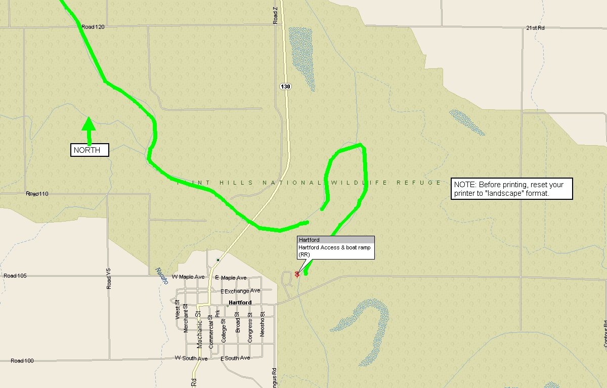
Neosho Rapids, KS - Hartford, KS
- River Map
-Neosho Rapids put-in
- River Map
-Hartford take-out
- 9.0 river miles
- Put-in: Neosho Rapids, KS, located 3 miles South of I-35 on Hwy 130. then take South St.
East for ~1 mile to a bridge over the Neosho River. NOTE: This is still private land.
Put-in immediately below the bridge. Path is muddy at times. Park cars on the road,
well off any private land. Access in on RL
- Take-out: Hartford, KS on RR at a boat ramp 100 yards upstream from an old concrete arch
bridge.
- Borders a large portion of the Flint Hills National Wildlife Refuge, an 18,000
acre public reserve. No firearms allowed on the river.
- Caution: Watch for downed trees, strainers, and shallow rocky ledges.
Access is poor at the put-in, but good at the take-out
- 300 cfs / NOTE: The water level must be computed by adding the flow of the
gauges Neosho and Cottonwood Rivers at the following gauge stations: NEOSHO RIVER NEAR
AMERICUS + COTTONWOOD RIVER NEAR PLYMOUTH / Flow levels are easiest checked by
logging onto the Kansas USGS Real Time Gauge link under the KANSAS PADDLER Home Page Water Conditions for River
Runners page.
- Class II
Hartford, KS - Jacobs Creek Landing
- River Map
put-in & take-out map
-
- 8.0 river miles
- Put-in: Hartford, KS on RR at a boat ramp 100 yards upstream from an old concrete arch
bridge.
- Take-out: Jacobs Creek Landing boat ramp - RR. Go 3 miles South of Hartford on Hwy 130.
Turn east on 16th Rd. Continue for 4 miles to Jacobs Creek landing and boat ramp at the
end of a 1/2 mile gravel road.
- Borders the Flint Hills National Wildlife Refuge, an 18,000 acre public reserve.
No firearms allowed on the river.
- Caution: Watch for downed trees, strainers, and shallow rocky ledges.
Access is generally good
- 300 cfs / NOTE: The water level must be computed by adding the flow of the
gauges Neosho and Cottonwood Rivers at the following gauge stations: NEOSHO RIVER NEAR
AMERICUS + COTTONWOOD RIVER NEAR PLYMOUTH / Flow levels are easiest checked by
logging onto the Kansas USGS Real Time Gauge link under the KANSAS PADDLER Home Page Water Conditions for River
Runners page.
- Class II
Deep
Creek, South of Manhattan, KS: (East & South branches), w/2 sections listed
Exit 318 I-70 - Pillsbury
Crossing
11.0 river miles
Put-in: I-70, Exit 318 - low water bridge
Take-out: Bridge above Pillsbury Crossing or at
Pillsbury Crossing
Caution: rapids , barb wire strainers , log-jams, low-water bridges that become
low-head dams at high flows
very scenic
150 cfs - very hard to catch with a minimum flow / Flow levels
are easiest checked by logging onto the Kansas USGS Real Time Gauge link under the KANSAS
PADDLER Home Page Water Conditions
for River Runners page.
Class III
Pillsbury crossing - no shuttle
float - KDWP public access
Pillsbury crossing(Deep Creek Rd.)
Pillsbury crossing(Deep Creek Rd.)
Caution: Watch for drunken teenagers
Very protected from winds - short float (1/2 mile up & then back down)
Class I
Wildcat
Creek, West of Manhattan, KS:
Keats, KS to Manhattan, KS
- 6-12 river miles
- Put-in: Keats, KS -
"closed" bridge east of town. Best access is the South side, under
the bridge.
- Various Riley County Rd. bridges.
Alternate access is off Wildcat Creek Rd bridge
- Caution: watch for downed trees & strainers (lots of them) / Access is
very poor
- 200 cfs - very tough to catch with a minimum stream flow /
No gauge available / Must scout directly from the Keats, KS bridge access
- Class III
Clarks
Creek , West of Junction City, KS
- Upper
- 6.0 river miles
- Clarks Cr. Rd bridge, turn South at the intersection of Hwy 57 & Clarks Cr.
Rd.
- Hwy 57 bridge
- Caution: Watch for downed trees, strainers, and minor rapids / Access is poor
- Very scenic
- 200 cfs - very hard to catch with minimum flow / No gauge available / Must scout
directly from the bridge access
- Class II+
- Middle
- 8.0 river miles
- Hwy 57 bridge
- Ascher Rd. bridge
- Caution: Watch for downed trees, strainers, and minor rapids / Access is poor
- Very scenic
- 200 cfs - very hard to catch with minimum flow / No gauge available / Must scout
directly from the bridge access
- Class II-III
- Lower
- 7.0 river miles
- Ascher Rd. bridge
- Kansas River - Ogden by-pass bridge
- Caution: Watch for downed trees & strainers / Access is poor
- Very scenic
- 200 cfs - moderately hard to catch with minimum flow / No
gauge available / Must scout directly from the bridge access
- Class II-III
Easy Stream Floats w/no shuttle required:
- Big Blue River: Use the Hwy 24 launch. Float � mile down
to the Kaw and back up. ~.5-1 mile
- Tuttle
Creek River Pond, below the dam: Turn
at the River Rat bait shop, on Tuttle Cr. Blvd. Use the gravel canoe
access400 yds below the
"tubes" at File Creek (RR) - below the Tuttle Reservoir dam.
Ferry across
the Big Blue River channel to the River Pond. Paddle around Tuttle River Pond.
All public property on USACE land and on KDWP State Park land.
- Tuttle
Creek River Pond (Alternate Access). Use the free access off Rocky
Ford road, opposite the Little Grill restaurant/bar. Paddle around the island
on the River Pond.
- Pillsbury Crossing -
on Deep Creek, Kansas Dept. of Wildlife & Parks (KDWP)
property) - This is a 1-1.5 mile flatwater float upstream and back
downstream to the crossing. Don't miss walking down to see the falls
at Pillsbury Crossing. Take Hwy 177, south of Manhattan,
KS. Turn east on Deep Creek Rd. Continue for 4 miles until the
intersection of Pillsbury Crossing Rd. Turn onto Pillsbury Crossing
Rd. Continue to the KDWP entrance to Pillsbury Crossing. Park
your car on the banks above the crossing.
Other
Smaller Area Creeks w/(small water sheds/difficult landowner access issues):
- Lyons Creek
- varies
- Lyons Cr Rd. (near Junction City)
- Smoky Hill River
- Caution: minor rapids, strainers
- Class II
- Mill Creek or West Fork of Mill Cr.
- varies
- Alma, KS
- Maple Hill Road bridge or Kansas River
- Caution: minor rapids, strainers; difficult landowner access issues
- Class III
- McDowell Cr.
- varies
- South of I-70, near Manhattan,
- use McDowell Cr. Rd access or run to Kansas River & take out at the Hwy 177
Bridge access
- Caution: strainers, minor rapids
- Class III
- Humbolt Cr., a tributary to Clarks Cr.
- 5.0 miles
- Low water bridge, S of I-70
- Clarks Creek tributary, use Clarks Cr - Ascher Rd bridge take-out
- Caution: minor rapids, strainers
- Class II
- Numerous other small creeks with
small watersheds are runnable, but very difficult to catch with a minimum flow, landowner
permission not withstanding
(See the KANSAS PADDLER Home Page for the most current trip/event
schedules) www.kansas.net/~tjhittle
[Home] / [Mega-Index] / [Water Conditions]
You are visitor 47559 to this page.
 - River map - Hwy 177 -
Junction City, KS only
- River map - Hwy 177 -
Junction City, KS only - River map -
Waterville, KS to Blue Rapids, KS only
- River map -
Waterville, KS to Blue Rapids, KS only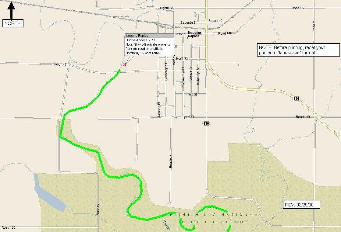 - River Map
-Neosho Rapids put-in
- River Map
-Neosho Rapids put-in
 - River Map
-Hartford take-out
- River Map
-Hartford take-out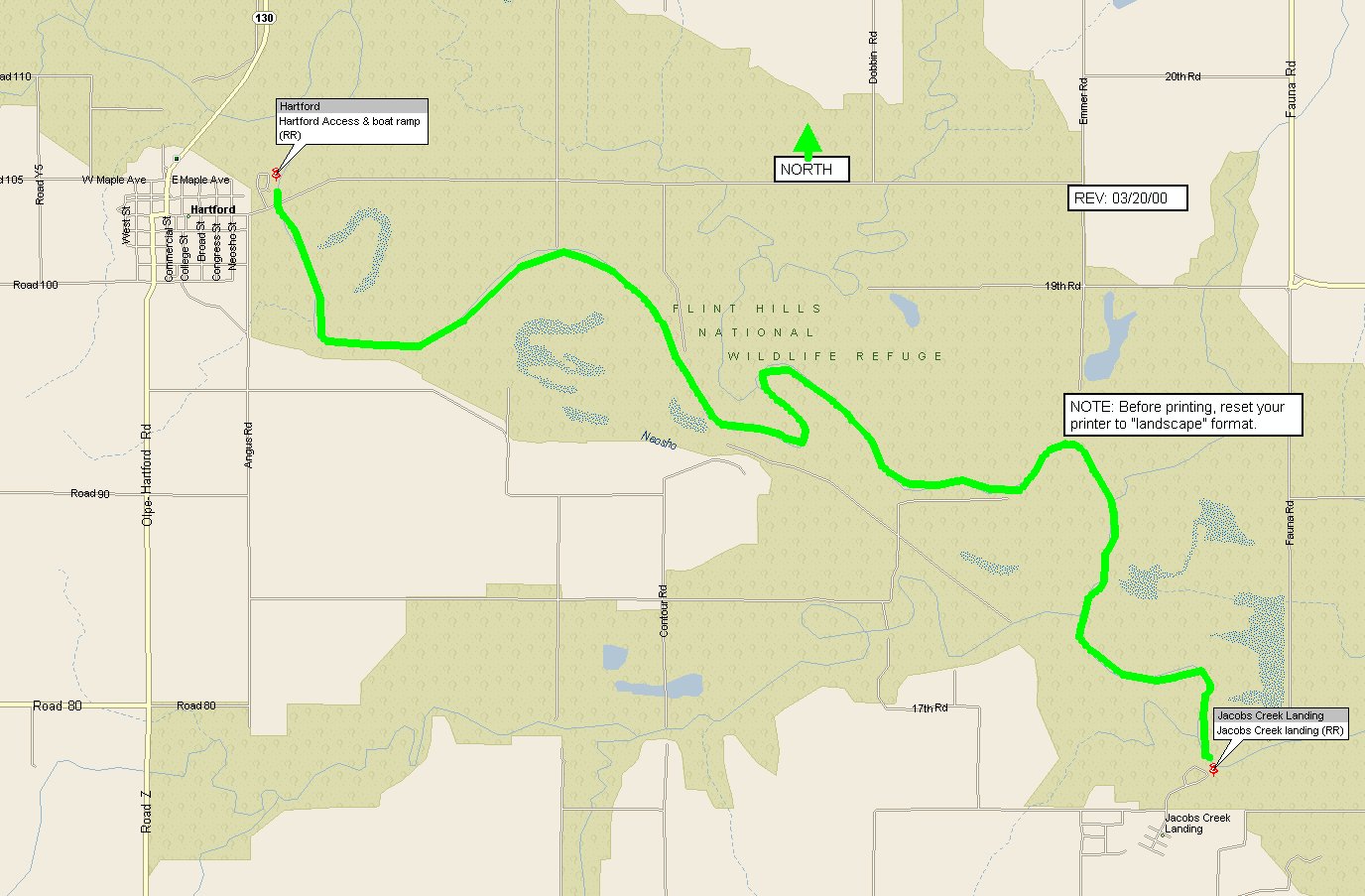 - River Map
put-in & take-out map
- River Map
put-in & take-out map